View updates by date:
| Aug. 25 | Aug. 24 | Aug. 23 | |
| Aug. 22 | Aug. 21 | Aug. 20 | Aug. 19 |
| Aug. 18 | Aug. 17 | Aug. 16 | Aug. 15 |
| Aug. 14 | Aug. 13 | Aug. 12 | Aug. 11 |
| Aug. 10 | Aug. 9 | Aug. 8 | Aug. 7 |
=============================================
MONDAY, AUGUST 25
|
Update 8/25/14 8:10 a.m.
97% contained – Excess crews and other resources being demobilized
IMT3 Mizer assumed command of the fire Saturday at 0600.
Fire behavior is minimal with only a few smokes deep within the interior of the fire perimeter.
Mop up and rehab of containment and contingency lines is ongoing.
Weather was favorable on Saturday with calm winds, moderate temperatures and humidity.
All air resources have been released from the incident, however DNR helicopters remain available if the need should arise.
Excess crews and other resources are being demobilized.
The following roads, trails and campgrounds near the closure are OPEN:
Taneum Road 3300 Open from I-90 until reaching the junction with Forest Road 3300-114.Taneum Rental Cabin –Open by reservation only.Ice Water Campground –OpenTaneum Junction Trailhead OpenForest Service Road 3350 –OpenForest Service Road 4510 – Open to its junction with Road 114.Gooseberry Trail #1227Little Creek Basin Trail #1334North Ridge Trail # 1321Granite Creek Trail #1326.1Fishhook Flats Trail #1378Taneum Ridge Trail #1363South Fork Taneum Trail #1367North Fork Taneum Trail #1377 – Open from its eastern terminus to it junction with Trail #1378, and from its junction with #1367.South Cle Elum Ridge Trail #1326 –Open from its eastern terminus to its crossing of Road 114, and from its junction with #1334.
The following roads, trails and campgrounds in the closure order are CLOSED:Forest Service Road 3300 from its junction with Road 114.Forest Service Road 4510 from its junctions with Roads 3300 and 114.Forest Service Road 114Taneum CampgroundSouth Cle Elum Ridge Trail #1326 from its crossing of Road 114 to its junction with Trail #1334.North Fork Taneum Trail #1377 from its junction with #1378 to its junction with #1367.Lightning Point Trail #1377.2
S.O. Order: _884__
AREA CLOSURE for PUBLIC SAFETY
OKANOGAN-WENATCHEE NATIONAL FOREST Pursuant to 36 CFR 261.50(a) and (b), the following acts are prohibited on the Okanogan-Wenatchee National Forest:
To go into or be upon any area closed for protection of public health or safety. For the purposes of this order, it is prohibited to enter or be within National Forest System lands, roads, or trails within the area of the Cle Elum Ranger District closure area consisting of: Taneum Road 3300 at the junction of Road 3300-114 then following 3300 westward to the junction for Road 4510 whereupon the closure boundary proceeds north then east to the junction with Road 114 which it follows to the point of origin per this closure description. Refer to the closure area map as shown in Exhibit A. Included in this closure are: the segment of Trail 1326 closed where it crosses Road 114 ( T19N, R15E, Section 18) and proceeds westward to its junction with Trail 1334 (T19N, R14E, Section 16); the segment of Trail 1377 from its junction with Trail 1378 to its junction with Trail 1367 (T19N, R14E, Section 26); the entirety of Trail 1377.2. This closure is effective as of August 22 , 2014 and will remain in effect until terminated.
Pursuant to 36 CFR 261.50(e), the following persons are exempt from this order:
1. Persons with a permit specifically authorizing the otherwise prohibited act or omission, including Washington State employees in performance of an official duty and their authorized contractors.
2. Any Federal, State or local officer or a member of any organized search and rescue, emergency services or firefighting force in the performance of an official duty.
3. Any private land owner exercising an existing right to access their own private property which is otherwise within the closure area as described above.
This prohibition is in addition to the general prohibitions in 36 CFR Part 261, Subpart A.
Done at Wenatchee, Washington this 22nd day of August, 2014.
/s/ Michael L. BalboniMichael L. BalboniForest SupervisorOkanogan-Wenatchee National Forest
Violations of these prohibitions are punishable by a fine of not more than $5,000 for an individual or $10,000 for an organization, or imprisonment for not more than 6 months, or both. (16 USC 551 and 18 USC 3559 and 3571).
Intent of Closure: To provide for public safety during the time that wildfire hazards remain.
Basic Information
- Current as of 8/25/2014, 8:09:59 AM
- Incident Type: Wildfire
- Cause: Lightning/natural
- Date of Origin: Thursday August 07th, 2014 approx. 05:00 PM
- Location: 7 miles southwest of South Cle Elum, Washington
- Incident Commander: Ty Mizer
- Incident Description: Wildfire
Current Situation
- Total Personnel: 124
- Size: 894 Acres
- Percent of Perimeter Contained: 97%
- Fuels Involved: Moderately heavy fuel loading (FM10) consisting of very mature trees, down wood, snags, brush and logging slash.
- Significant Events: Occasional smoldering of interior islands.
Outlook
- Planned Actions: Crews will continue to patrol and mop up any spots found. Rehab of fire suppression activities will continue.
- Projected Incident Activity: No fire activity is expected.
- Remarks: Rehab work continues with 80-85% of the identified rehabilitation on this fire having been completed to date. Gradual demobilization of suppression and rehabilitation resources will continue through the nexe 3-5 days
Current Weather
- Weather Concerns: An upper ridge of high pressure will bring the return of hot and dry conditions lasting through late in the week.
=============================================
SATURDAY, AUGUST 23 |
Update 8/23/14
The area closure on the South Cle Elum Ridge Fire has been reduced to include the footprint of the fire and surrounding areas that are still being impacted by suppression and mop up activities. Forest visitors are reminded that fire traffic continues to travel roads accessing the fire. Use caution and yield to fire traffic.
=============================================
FRIDAY, AUGUST 22 |
Update 8/22/14 1:15 p.m.
Fire information remains nearly the same as yesterday, total personnel reduced from 269 to 174
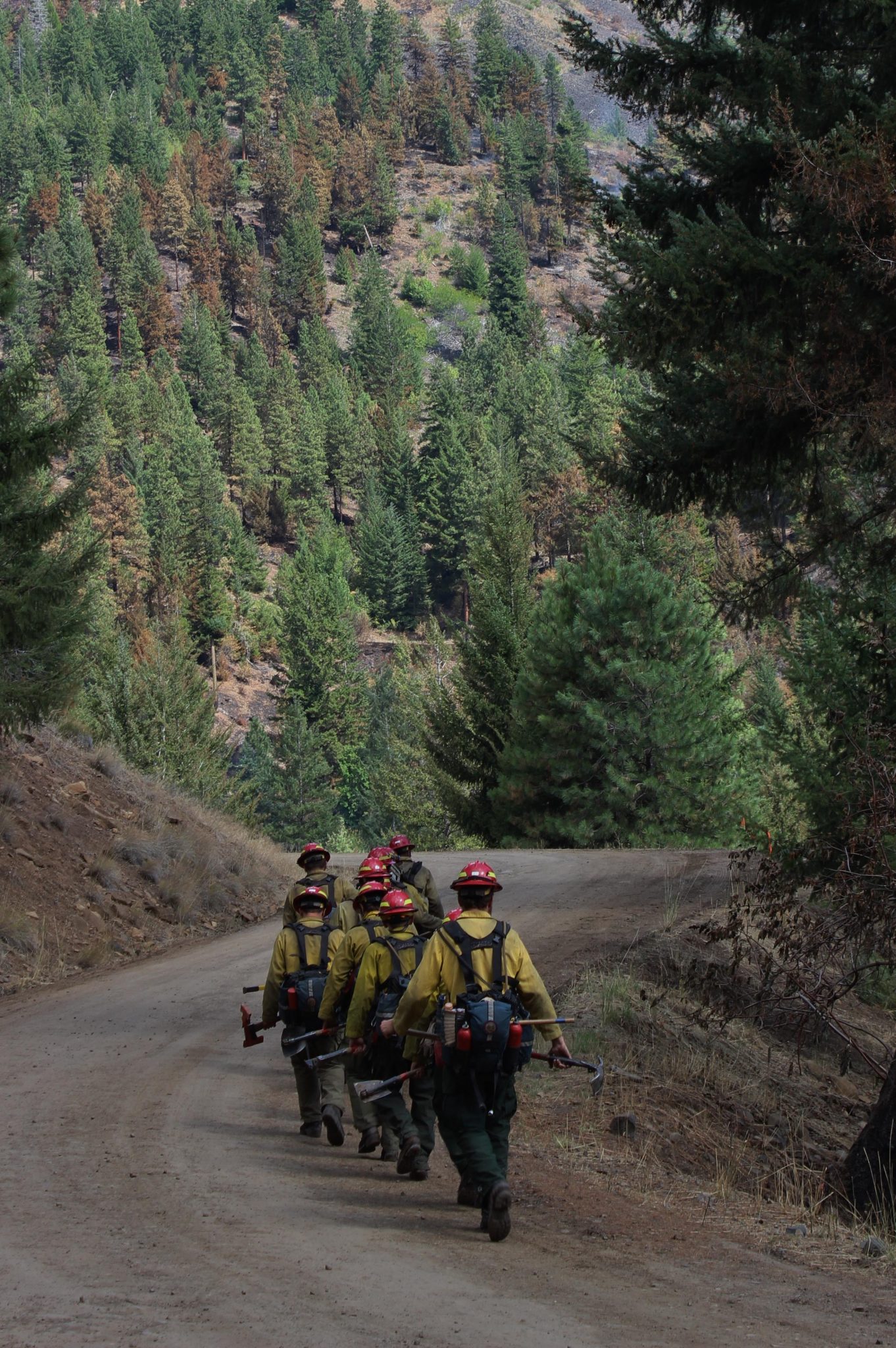
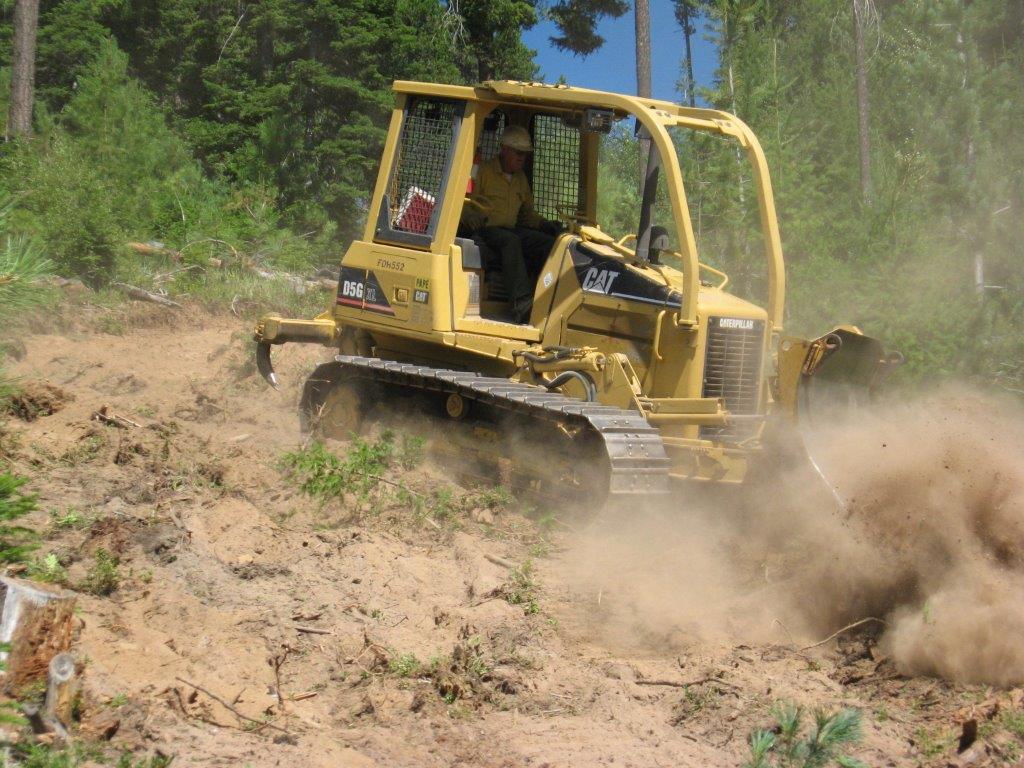
Crew walking in to South Cle Elum Ridge Fire operations – photo courtesy of USFS
Basic Information
- Current as of 8/22/2014, 1:14:26 PM
- Incident Type: Wildfire
- Cause: Lightning/natural
Current Situation
- Total Personnel 174
- Size 894 Acres
- Percent of Perimeter Contained 93%
- Significant Events: Very minimal fire behavior was observed. Some interior heavy fuels continue to burn.
Outlook
- Planned Actions: Crews will continue to patrol and mop up any spots found. Rehab of fire suppression activities will occur.
- Projected Incident Activity: No fire activity is expected.
- Weather Concerns: Isolated thunderstorms were observed in the vicinity of the fire area. Drier air aloft mixed down in the afternoon causing lower humidities of 22-25%. Showers and thunderstorms are likely tomorrow afternoon.
=============================================
THURSDAY, AUGUST 21 |
Update 8/21/14 8:10 a.m.
Fire containment level now 93%
Incident Overview
Firelines were tested yesterday as a wind event moved through the area bringing erratic winds with gusts up to 30 mph. Firefighters observed minimal smoldering fire behavior. There are a few areas on the southwest side of the fire with heavy concentrations of fuels that require mop-up.
The Forest Service closure in the area of the South Cle Elum Ridge Fire is still in place. The area closure includes all roads and trails within that area. Be sure you know where you are and that you are not violating the closure. It is being strictly enforced.
Evacuation Notice removed: 08/18/14 – The Kittitas County Emergency Operations Center has removed the Level 1 evacuation notice for Woods and Steele Road. Roadblocks for the South Cle Elum Ridge Fire will remain in place for Forest Service Road 4510, Forest Service Road 3350 at the junction with Forest Service Road 119, and at Forest Service Road 3300 at the South Fork Taneum Creek bridge.
Basic Information
- Incident Type: Wildfire
- Cause: Lightning/natural
- Date of Origin: Thursday August 07th, 2014 approx. 05:00 PM
- Location: 7 miles southwest of South Cle Elum, Washington
- Incident Commander: Doug Turman
- Incident Description: Wildfire
Current Situation
- Total Personnel: 269
- Size: 894 Acres
- Percent of Perimeter Contained: 93%
- Fuels Involved: Moderately heavy fuel loading consisting of very mature trees, down wood, snags, brush and logging slash.
- Significant Events: Fire activity was primarily smoldering. A few areas with heavy concentrations of fuels continue to be of concern.
Outlook
- Planned Actions: Complete any incomplete direct line construction. Mop up 50 to 100 feet in from fire edge. Continue rehab work where possible.
- Projected Incident Activity: Minimal fire activity is expected in the next 24 hours. The fuel moisture in the heavy fuels are still low and will continue to burn out. If the predicted cold front, with higher winds occurs, there is a chance for an increase in burning activity.
- Remarks: Evacuation alerts have been lifted. The Fire has many challenges with access issues, steep terrain and snag hazards.
Current Weather
- Weather Concerns: Today’s conditions will be breezy with winds of 5-10 mph observed. Temperatures at 70-75 with humidity between 23-30%. Tomorrow’s conditions are expectted to be similar with slightly less winds.
===================================
WEDNESDAY, AUGUST 20 |
Update 8/20/14 7:15 a.m.
87% Contained – smoldering fire behavior with a few areas requiring mop-up / transitioning to Type 3 team Friday
Message from Incident Information Office: This will be the last sent update for the South Cle Elum Ridge Fire. For information about this wildfire, please visit www.inciweb.nwcg.gov or call Cle Elum Ranger District at (509) 852-1100.
Northern Rockies Type 1 team will transition with a Type 3 team Friday.
Current Situation: Firelines were tested yesterday as a wind event moved through the area bringing erratic winds with gusts up to 30 mph. Firefighters observed minimal smoldering fire behavior. There are a few areas on the southwest side of the fire with heavy concentrations of fuels that require mop-up.
The Forest Service closure in the area of the South Cle Elum Ridge Fire is still in place. The area closure includes all roads and trails within that area. Be sure you know where you are and that you are not violating the closure. It is being strictly enforced.
Weather Outlook: Today will continue to be breezy with west/northwest winds of 10-15 mph with gusts to 23. Temperatures are expected to be between 65-77 with humidities between 23-34%.
Forest Closures: For public and firefighter safety the Okanogan-Wenatchee National Forest has issued an Area Closure in the Taneum Creek Area. Road blocks are in place on Forest Road 4510 (Woods and Steele Road), junction of Forest Roads 3350 and 119 (Five Corners) and Forest Road 3300 at the Bridge across the South Fork Taneum Creek.
A campfire ban is currently in place for all forested lands in Kittitas County. It is extremely important that forest visitors and campers continue to cooperate and support local firefighting efforts by having no campfires.
For US Forest area closure information contact: Cle Elum Ranger District: (509) 852-1100 Monday through Friday 8-4:30pm.
Evacuation Information: The Kittitas County Emergency Operations Center removed the Level 1 evacuation 8/18/14, for the Woods & Steele Road.
Cooperating Agencies: The Okanogan-Wenatchee National Forest, Washington State Department of Natural Resources, Kittitas County Fire Districts 7 and 1, Kittitas County Sheriff’s Office and the Washington State National Guard.
FIRE STATUS
- Acres Burned: 894 acres
- Containment: 87%
- Structures Destroyed: 0
- Closures: Closure Area for Taneum Creek on Cle Elum Ranger District, Campfire Ban
- Cause: Lightning/Natural
RESOURCES
- Crews: 8
- Engines: 19
- Dozers: 5
- Helicopters: 0
- Total personnel: 327
- Injuries: 6
=============================================
TUESDAY, AUGUST 19 |
Update 8/19/14 8:20 a.m.
Wind event moving through area with gusts up to 30 mph will test firelines today
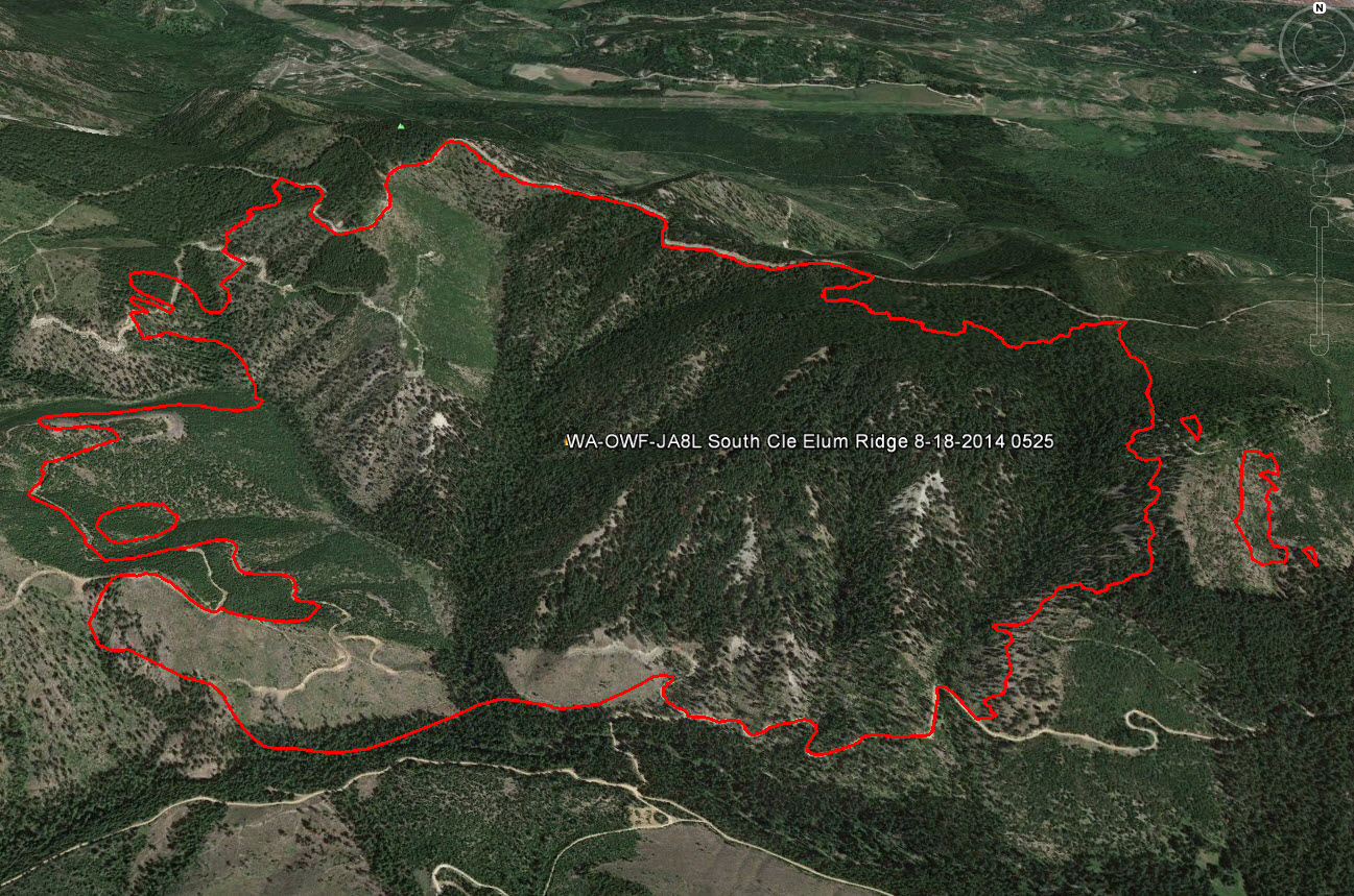
South Cle Elum Fire Perimeter as of 8/18/14. Total acres burned as of the 8/19/14 incident report are 894 acres. Image courtesy of Google Earth/GeoMAC wildfire mapping viewer.
Current Situation: Firelines will be tested today as a wind event moves through the area bringing erratic winds with gusts up to 30 mph. Minimal fire behavior is expected, but as the weather warms and fuels dry, the potential for more active behavior will increase. Un-detected hot spots could show with the windy conditions. Air resources are available from the Snag Canyon Fire.
The Forest Service closure in the area of the South Cle Elum Ridge Fire is still in place. The area closure includes all roads and trails within that area. Be sure you know where you are and that you are not violating the closure. It is being strictly enforced.
Weather Outlook: A dry cold front will quickly push through this morning allowing gusty west-northwest winds to develop over the fires. Possibility of a thunderstorm with gusty erratic winds to 30 mph is possible.
Forest Closures: For public and firefighter safety the Okanogan-Wenatchee National Forest has issued an Area Closure in the Taneum Creek Area. Road blocks are in place on Forest Road 4510 (Woods and Steele Road), junction of Forest Roads 3350 and 119 (Five Corners) and Forest Road 3300 at the Bridge across the South Fork Taneum Creek.
A campfire ban is currently in place for all forested lands in Kittitas County. It is extremely important that forest visitors and campers continue to cooperate and support local firefighting efforts by having no campfires.
For US Forest area closure information contact: Cle Elum Ranger District: (509) 852-1100 Monday through Friday 8-4:30pm.
Evacuation Information: The Kittitas County Emergency Operations Center removed the Level 1 evacuation 8/18/14, for the Woods & Steele Road.
Cooperating Agencies: The Okanogan-Wenatchee National Forest, Washington State Department of Natural Resources, Kittitas County Fire Districts 7 and 1, Kittitas County Sheriff’s Office and the Washington State National Guard.
FIRE STATUS
- Acres Burned: 894 acres
- Containment: 77%
- Structures Destroyed: 0
- Closures: Closure Area for Taneum Creek on Cle Elum Ranger District, Campfire Ban
- Cause: Lightning/Natural
RESOURCES
- Crews: 8
- Engines: 20
- Dozers: 5
- Helicopters: 0
- Total personnel: 337
- Injuries: 6
=====================================
MONDAY, AUGUST 18 |
Update 8/18/14 11:15 a.m.
Level 1 Evacuation Notice for Woods & Steele Road Removed
The Kittitas County Emergency Operations Center has removed the Level 1 evacuation notice for Woods & Steele Road, as the South Cle Elum Ridge Fire is now 77% contained.
Roadblocks for the South Cle Elum Ridge Fire will remain in place for Forest Service Road 4510, Forest Service Road 3350 at the junction with Forest Service Road 119, and at Forest Service Road 3300 at the South Fork Taneum Creek bridge.
The Snag Canyon Fire evacuation levels and roadblocks remain the same. The fire is now 76% contained. Fire operations are expecting a wind event for Tuesday morning, and while they feel they will maintain control of the fire, the evacuation levels will remain in place as a precaution.
Anyone with questions can contact the Emergency Operations Center at 509-933-8305, or contact the Fire Information Office at 509-731-3641.
Kittitas County, from the Cascades to the Columbia, and online at https://www.co.kittitas.wa.us
====================================================
Update 8/18/14 8:00 a.m.
Existing Lines Being Reinforced in Preparation for Winds Associated with a Cold Frontal Passage Forecast Tomorrow

VLAT (Very Large Airtanker) photo courtesy of USFS
Current Situation: Yesterday firefighters completed building direct lines on the northeastern corner of the fire, south of the 4510 Road. Today they will clean up and reinforce those lines. On the northwest corner of the fire, existing lines are also being reinforced, in preparation for winds associated with a cold frontal passage forecast tomorrow. Benign fire behavior is expected today, but as the weather warms and fuels dry, the potential for more active behavior will increase. Air resources are available from the Snag Canyon Fire.
The Forest Service closure in the area of the South Cle Elum Ridge Fire is still in place. The area closure includes all roads and trails within that area. Be sure you know where you are and that you are not violating the closure. It is being strictly enforced.
Weather Outlook: It will be warm and dry today with a slight chance of showers and thunderstorms over the fire area. Tomorrow is expected to be windy as a cold front passes through the area.
Forest Closures: For public and firefighter safety the Okanogan-Wenatchee National Forest has issued an Area Closure in the Taneum Creek Area. Road blocks are in place on Forest Road 4510 (Woods and Steele Road), junction of Forest Roads 3350 and 119 (Five Corners) and Forest Road 3300 at the Bridge across the South Fork Taneum Creek.
A campfire ban is currently in place for all forested lands in Kittitas County. It is extremely important that forest visitors and campers continue to cooperate and support local firefighting efforts by having no campfires
For US Forest area closure information contact: Cle Elum Ranger District: 509.852.1100 Monday through Friday 8-4:30pm.
Evacuation Information: No change in evacuation levels. There continues to be a Level 1 evacuation advisement for the 15 homes over a mile away from the fire on the Woods and Steele Road. [see update from 11:15 a.m. above – evacuation notice now removed]
Cooperating Agencies: The Okanogan-Wenatchee National Forest, Washington State Department of Natural Resources, Kittitas County Fire Districts 7 and 1, and Kittitas County Sheriff’s Office.
FIRE STATUS
- Acres Burned: 894 acres
- Containment: 77%
- Structures Destroyed: 0
- Closures: Closure Area for Taneum Creek on Cle Elum Ranger District, Campfire Ban
- Cause: Lightning/Natural
RESOURCES
- Crews: 9
- Engines: 24
- Dozers: 5
- Helicopters: 0
- Total personnel: 371
- Injuries: 6
================================================
SUNDAY AUGUST 17 |
Update 8/17/14 7:30 a.m.
Fire Reported 77% Contained – no increase in acreage over last 4 days

“Bucket Work” – photo courtesy of USFS
Current Situation: There was no increase in acreage over the last four days. A high pressure system dominated the area yesterday with drier, warmer and windier conditions. Crews continued to strengthen the containment lines. Today firefighters will once again be concentrating on the northeastern corner working directly on the fire edge improving the line. The high level Infrared flight last night identified a few remaining hot spots.
The fire is not expected to spread today but it will be mainly smoldering in the thick duff layers and heavy, downed timber in the interior of the fire area.
The Forest Service closure in the area of the South Cle Elum Ridge Fire is still in place. The area closure includes all roads and trails within that area. Be sure you know where you are and that you are not violating the closure. It is being strictly enforced.
Weather Outlook: It will be slightly warmer and drier today with a very slight chance of thunderstorms in the area. Warmer and dryer conditions with light winds will continue through Monday.
Forest Closures: For public and firefighter safety the Okanogan-Wenatchee National Forest has issued an Area Closure in the Taneum Creek Area. Road blocks are in place on Forest Road 4510 (Woods and Steele Road), junction of Forest Roads 3350 and 119 (Five Corners) and Forest Road 3300 at the Bridge across the South Fork Taneum Creek.
A campfire ban is currently in place for all forested lands in Kittitas County. The forests are still extremely dry despite the recent rain. It is extremely important that forest visitors and campers continue to comply with the ban to help prevent new fires.
For US Forest area closure information contact: Cle Elum Ranger District: 509.852.1100 Monday through Friday 8-4:30pm.
Evacuation Information: No change in evacuation levels. There continues to be a Level 1 evacuation advisement for the 15 homes over a mile away from the fire on the Woods and Steele Road.
Cooperating Agencies: The Okanogan-Wenatchee National Forest, Washington State Department of Natural Resources, Kittitas County Fire Districts 7 and 1, and Kittitas County Sheriff’s Office.
FIRE STATUS
- Acres Burned: 894 acres
- Containment: 77%
- Structures Destroyed: 0
- Closures: Closure Area for Taneum Creek on Cle Elum Ranger District, Campfire Ban
- Cause: Lightning suspected; formal investigation pending
RESOURCES
- Crews: 10
- Engines: 27
- Dozers: 5
- Helicopters: 1
- Total personnel: 397
- Injuries: 6
======================================
SATURDAY, AUGUST 16 |
Update 8/16/14 7:05 a.m.
Heads up – area, road and trail closures are being enforced
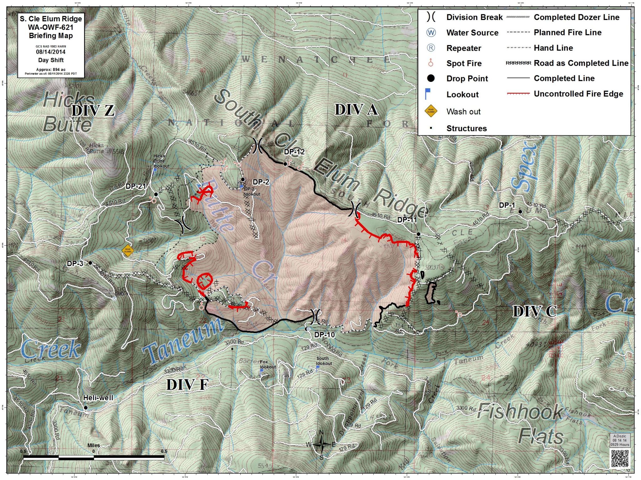
Fire perimeter 8/14/14 – map courtesy of USFS.
Current Situation: There was no increase in acreage over the last three days. Even though there was no measurable rain over the fire area yesterday cooler temperatures and higher humidity aided firefighting efforts. Crews continued to strengthen the containment lines mopping up 60 feet in. Today with the favorable weather conditions, firefighters will be concentrating on the northeastern corner working directly on the fire edge to get a line in.
The fire is not expected to spread today but it will continue creeping and smoldering in the thick duff layers in the interior of the fire area.
The Forest Service closure in the area of the South Cle Elum Ridge Fire is still in place. The area closure includes all roads and trails within that area. Be sure you know where you are and that you are not violating the closure. It is being strictly enforced.
Weather Outlook: It will be slightly warmer and drier today with a slight chance of showers and thunderstorms over the fire area. Warmer and dryer conditions will continue through Monday.

Area Closure and fire perimeter map for the South Cle Elum Ridge Fire, as of 8/14/14 – click to enlarge. Map courtesy of USFS
Forest Closures: For public and firefighter safety the Okanogan-Wenatchee National Forest has issued an Area Closure in the Taneum Creek Area. Road blocks are in place on Forest Road 4510 (Woods and Steele Road), junction of Forest Roads 3350 and 119 (Five Corners) and Forest Road 3300 at the Bridge across the South Fork Taneum Creek.
A campfire ban is currently in place for all forested lands in Kittitas County. It is extremely important that forest visitors and campers continue to cooperate and support local firefighting efforts by having no campfires
For US Forest area closure information contact:Cle Elum Ranger District: 509.852.1100 Monday through Friday 8-4:30pm.
Evacuation Information: No change in evacuation levels. There continues to be a Level 1 evacuation advisement for the 15 homes over a mile away from the fire on the Woods and Steele Road.
Cooperating Agencies: The Okanogan-Wenatchee National Forest, Washington State Department of Natural Resources, Kittitas County Fire Districts 7 and 1, and Kittitas County Sheriff’s Office.
FIRE STATUS
- Acres Burned: 894 acres
- Containment: 70%
- Structures Destroyed: 0
- Closures: Closure Area for Taneum Creek on Cle Elum Ranger District, Campfire Ban
- Cause: Lightning suspected; formal investigation pending
RESOURCES
- Crews: 13
- Engines: 40
- Dozers: 5
- Helicopters: 4
- Total personnel: 493
- Injuries: 6
=========================================
FRIDAY, AUGUST 15 |
Update Aug. 15, 2014 8:55 a.m.
Northern Rockies Type 1 Team assumed management of South Cle Elum Ridge and Snag Canyon Fires Today
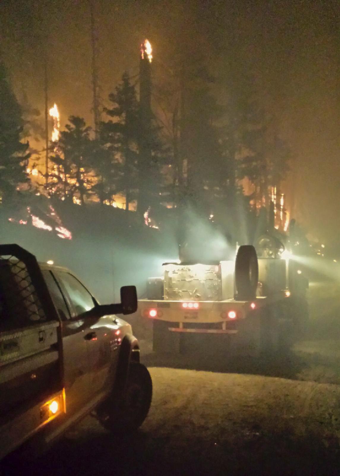
Night Shift – photo courtesy of USFS
At 6:00 a.m. this morning the Northern Rockies Type 1 Team assumed management of both large fires in Kittitas County, the Snag Canyon Fire and the South Cle Elum Ridge Fire.
Current Situation: There was no increase in acreage yesterday. Firefighters were successful in getting a line around the western flank of the fire. Additional rain and cool temperatures aided firefighters in further strengthening the containment lines on the north and south flanks. Today firefighters will be concentrating on the northeastern flank. They will be thinning and removing vegetation in unburned areas between the line and the main fire area. If conditions are favorable they will stack and burn the thinned fuels.
The fire is not expected to spread today but it will continue creeping and smoldering in the thick duff layers in the interior of the fire area.
Weather Outlook: A cool, moist and unsettled weather pattern will continue over the Cle Elum Ridge Fire. There is a chance of showers and thunderstorms over the fire area today. Warmer and dryer conditions are expected beginning on Sunday
Forest Closures: For public and firefighter safety the Okanogan-Wenatchee National Forest has issued an Area Closure in the Taneum Creek Area. Road blocks are in place on Forest Road 4510 (Woods and Steele Road), junction of Forest Roads 3350 and 119 (Five Corners) and Forest Road 3300 at the Bridge across the South Fork Taneum Creek.
A campfire ban is currently in place for all forested lands in Washington State. It is extremely important that forest visitors and campers continue to cooperate and support local firefighting efforts by having no campfires
For US Forest area closure information contact: Cle Elum Ranger District: 509.852.1100 Monday through Friday 8-4:30pm.
Evacuation Information: No change in evacuation levels. There continues to be a Level 1 evacuation advisement for the 15 homes over a mile away from the fire on the Woods and Steele Road.
Cooperating Agencies: The Okanogan-Wenatchee National Forest, Washington State Department of Natural Resources, Kittitas County Fire Districts 7 and 1, and Kittitas County Sheriff’s Office.
FIRE STATUS
- Acres Burned: 894 acres
- Containment: 60%
- Structures Destroyed: 0
- Closures: Closure Area for Taneum Creek on Cle Elum Ranger District, Campfire Ban
- Cause: Lightning suspected; formal investigation pending
RESOURCES
- Crews: 13
- Engines: 41
- Dozers: 2
- Helicopters: 6
- Total personnel: 548
- Injuries: 6
=======================================
THURSDAY, AUGUST 14 |
Update Aug. 14, 2014 9:15 a.m
A third firefighter was injured yesterday in a vehicle accident

South Cle Elum Ridge Fire – photo courtesy of the USFS
Yesterday: Firefighters worked to secure the containment line on the north flank of the fire along the 4510 road by eliminating all smokes and hot spots within 75 feet of the line, further minimizing threat to the residents on the Woods & Steele road. Good progress was made constructing a line around the rugged western edge of the fire. Three firefighters were injured yesterday: two were struck in the leg by a rolling log, and one by a vehicle accident. All three were transported to hospitals. Two of the firefighters have already been released and are back at work. The other is doing well, but is still being evaluated.
Today: A Safety Standdown for all personnel was held this morning. Safety Officers reviewed hazards on the incident and actions needed to minimize risk.
On the western edge of the fire in the Butte Creek drainage firefighters will be working to complete a handline. Firefighters have a good handle on both the northern flank along the 4510 road and the southern edge along the 114 road and above the 3300 road. In those areas they will be further securing the existing lines by mopping up and reducing fuels.
Today is the last operational shift for Washington Incident Management Team 3. Tomorrow at 0600, Northern Rockies Type 1 Team will be assuming management of the fire. They will be shadowing the current management team during the day today. This team transition will result in both large fires in Kittitas County under the leadership of one incident management team.
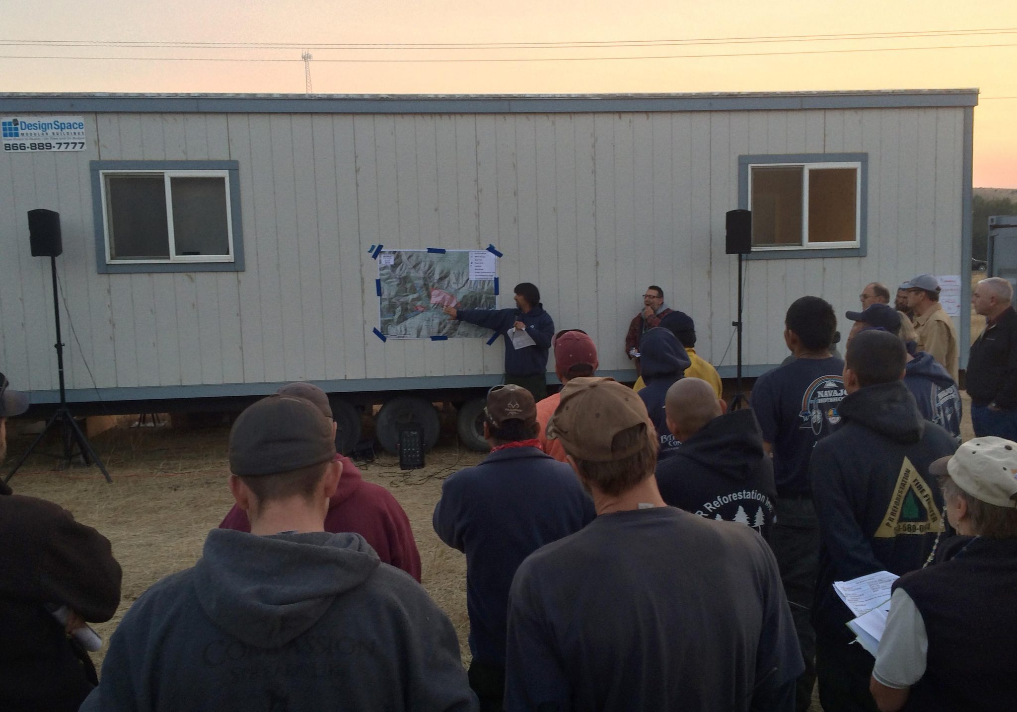
Informational Meeting: There will be an informational meeting tonight at the Cle Elum Senior Center at 719 East 3rd Street in Cle Elum at 7:00 PM for updates on the South Cle Elum Ridge Fire and information on the Snag Fire outside of Ellensburg
Weather Outlook: A cool, moist and unsettled weather pattern will continue over the Cle Elum Ridge Fire with today being the wettest day of the week. Showers and thunderstorms are likely in the afternoon. There is a flash flood watch in effect for the fire area.
Closures/Evacuation: No change in evacuation levels. There continues to be a Level I evacuation advisement for the homes on the Woods & Steele Road. For public and firefighter safety the Okanogan-Wenatchee National Forest has issued an Area Closure in the Taneum Creek Area.Forest area closure information contact: Cle Elum Ranger District: 509.852.1100 Monday through Friday 8-4:30pm.
Cooperating Agencies: The Okanogan-Wenatchee National Forest, Washington State Department of Natural Resources, Kittitas County Fire Districts 7 and 1, and Kittitas County Sheriff
FIRE STATUS
- Acres Burned: 894 acres
- Containment: 24%
- Structures Destroyed: 0
- Closures: Closure Area for Taneum Creek on Cle Elum Ranger District, Campfire Ban
- Cause: Lightning suspected; formal investigation pending
RESOURCES
- Crews: 12
- Engines: 40
- Dozers: 2
- Helicopters: 2
- Total personnel: 517
- Injuries: 6
===================================
WEDNESDAY, AUGUST 13 |
Update Aug. 13, 2014 7:14 p.m.
Evening Update – Two firefighters injured by rolling log today; precipitation and cooler temps lead to progress made on fire lines
Firefighters made progress getting handline in on the west flank of the fire today. Progress was also made in holding and strengthening containment lines along the South Cle Elum Ridge. With the cooler temperatures and the precipitation that fell overnight they were able to work directly on the fire edge. Though fire intensity decreased considerably in the lighter fuels, the fire remains active within the interior amongst pockets of heavier fuel.
Early this afternoon, two firefighters from the Arizona based Navajo Hot Shot crew were injured on the South Cle Elum Ridge Fire. A large log rolling down a steep slope hit the two firefighters. Both firefighters were transported and are being treated at Harborview Medical Center in Seattle, WA for lower leg injuries. Both firefighters are in stable condition and receiving treatment for their injuries.
Crews on the South Cle Elum Ridge Fire are working in a heavily forested area. Hazards include; steep slopes, standing trees weakened by fire, woody debris and rocks that can break loose and roll downhill.
========================================
Update Aug. 13, 2014 2:35 p.m.
Fire Danger Prompts BLM to Prohibit Campfires in Eastern Washington
EASTERN WA – Extreme fire danger has prompted Bureau of Land Management (BLM) fire managers to prohibit campfires in Eastern Washington, including in developed recreation areas. Managers implemented initial fire restrictions in mid-July and have updated them to prohibit the building, maintaining, attending or using a fire of any type, including charcoal briquette fires on lands administered by the BLM’s Spokane District. An exemption is made for liquefied and bottled gas stoves and heaters provided they are used within an area at least 10 feet in diameter that is barren or cleared of all flammable material.
The updated fire restriction will be effective beginning at 12:01 a.m. on Thursday, August 14, 2014.
Fire restrictions apply to all BLM managed lands in the following Eastern Washington counties: Adams, Asotin, Benton, Chelan, Columbia, Douglas, Ferry, Franklin, Garfield, Grant, Kittitas, Klickitat, Lincoln, Okanogan, Pend Oreille, Spokane, Stevens, Walla Walla, Whitman, and Yakima counties. Restrictions are in place until further notice.
In addition to prohibiting campfires, restrictions on the use of off-road vehicles, smoking, shooting of exploding targets and the use of fireworks is still in effect. A complete, signed fire restriction order can be found at the following websites:
==============================================
Update Aug. 13, 2014 9:30 a.m.
Changing Weather Conditions Contribute to Improved Air Quality
At 7:00 am today, air quality is good, according to the Washington State Department of Ecology air quality monitoring site in Ellensburg. The range of air quality categories include good, moderate, unhealthy for sensitive groups, unhealthy, very unhealthy, and hazardous.
Changing weather conditions and fire activity contribute to changing air quality. Current air quality monitoring can be seen on the Washington State Department of Ecology air monitoring site: https://fortress.wa.gov/ecy/enviwa/.
Air quality closer to the active burn site may be poorer air quality than what the monitor in Ellensburg reflects. Information about using visibility to estimate air quality is available at https://www.deq.state.or.us/aq/burning/wildfires/visibility.htm.
The Kittitas County Public Health Department (KCPHD) will continue to provide information regarding air quality status. For more information or questions about air quality please contact the Kittitas County Public Health Department at (509) 962-7515.
=============================================
Update Aug. 13, 2014 8:00 a.m.
The change in weather pattern was favorable for firefighters on the South Cle Elum Ridge Fire Tuesday

South Cle Elum Ridge Fire perimeter map, with closures, 8/12/14 – courtesy of the USFS
The fire continued to burn to the west, the northeast and to the south, but with a lower intensity than earlier this week. There was only one hour of full sun on the fire, but even with the cooler temperatures and higher humidity, during that single hour fire activity picked up and in places moved into the treetops. West winds helped push the fire in on itself on the western flank and upslope winds on the east flank slowed fire progress to the east.
Today: The fire is 15% contained and crews will be mopping-up and searching for any hot spots close to the line on the northwest corner and along the north edge. On the east flank the cool damp weather will provide good opportunities for crews to burn pockets of unburned larger fuels that could threaten the line. The heavier fuels are still dry and will burn, but the lighter fuels, grass and shrubs, are less likely to carry fire today.
Due to very high fire danger a campfire ban is currently in place on the Okanogan-Wenatchee Forest and all state and private forested lands in Washington. Even with the moisture received over the past 24-hours fire danger is still high and local resources responded to numerous fire starts yesterday evening.
Forest Closures: For public and firefighter safety the Okanogan-Wenatchee National Forest has issued an Area Closure in the Taneum Creek Area. Road blocks are in place on Forest Road 4510 (Woods and Steele Road), junction of Forest Roads 3352 and 119 (Five Corners) and Forest Road 3300 at the Bridge across the South Fork Taneum Creek.
Weather Outlook: There is chance of showers or thunderstorms throughout the day on Wednesday. Heavy rain and gusty erratic winds up to 30 mph are possible with thunderstorms. There is a flash flood watch in effect for the South Cle Elum Ridge Fire today and tonight if there is heavy rain over the fire.
For US Forest area closure information contact: Cle Elum Ranger District: 509.852.1100 Monday through Friday 8-4:30pm.
Evacuation Information: No change in evacuation levels. There continues to be a Level I evacuation advisement for the 15 homes over a mile away from the fire on the Woods and Steele Road.
Cooperating Agencies: The Okanogan-Wenatchee National Forest, Washington State Department of Natural Resources, Kittitas County Fire Districts 7 and 1, and Kittitas County Sheriff’s Office.
=============================================
TUESDAY, AUGUST 12 |
Update Aug. 12, 2014 5:40 p.m.
Evening Update – Cooler temps, fire less active
With the cooler temperatures and higher humidity the fire has been less active than it was yesterday. Burning at a low intensity, the fire bumped up against the 4510 road on the northeast corner creating a good black line between the road and the interior of the fire. On the western side, the fire burned a pocket of trees in the Butte Creek drainage but has not made any major runs up the drainage. To the south, the fire also filled a portion of unburned fuel between the 3300 road and the main fire further strengthening the fireline in that area.
Fire managers are now watching the track of thunderstorms heading towards the fire and air resources are temporarily grounded for safety.
===================================
Update Aug. 12, 2014 4:50 p.m.
Another public meeting on Thursday
A second public meeting is planned for the South Cle Elum Ridge Fire on Thursday, August 14th, at 7:00pm at the Cle Elum Senior Center.
Kittitas County emergency managers and fire managers will be available to provide a fire update and answer questions.
===============================
Update Aug. 12, 2014 8:20 a.m.
A red flag warning is in effect until 5pm Wednesday for abundant lightning and gusty winds
Morning briefing, Aug. 11, 2014 – South Cle Elum Ridge Fire crews. Photo courtesy of the USFS.
Current Situation: Intense fire behavior made for a tough day yesterday for the firefighters working on the South Cle Elum Ridge Fire. The fire increased in size by of over 400 acres. According to Operation Section Chief Chris Williams, firefighters did an “Awesome Job”. With the aid of retardant drops from the VLAT, a DC-10 aircraft, firefighters were able to hold the line on the top of South Cle Elum Ridge. Firefighters were also successful in moderating the spread of the fire to the south and east. On the west side of the fire the two spots burned into the main fire and into the Butte Creek drainage. The fire is expected to continue to burn up the Butte Creek drainage during the day today.
With cooler temperatures, higher humidity and some light precipitation the fire should be less active than it has been in the last two days giving firefighters good opportunities to strengthen existing lines and construct line in areas where the fire expanded Monday.
Evacuation Information: No change in evacuation levels. There continues to be a Level I evacuation advisement for the 15 homes over a mile away from the fire on the Woods and Steele Road.
Forest Closures: For public and firefighter safety the Okanogan-Wenatchee National Forest has issued an Area Closure in the Taneum Creek Area. Road blocks are in place on Forest Road 4510 (Woods and Steele Road), junction of Forest Roads 3352 and 119 (Five Corners) and Forest Road 3300 at the Bridge across the South Fork Taneum Creek.
Due to very high fire danger a campfire ban (see notice below) is currently in place for all forested lands in Washington State. It is extremely important that forest visitors and campers continue to cooperate and support local firefighting efforts by having no campfires.
Weather Outlook: Thunderstorms are expected throughout the day on Tuesday. It will be partly cloudy with temperatures in the high 70s to low 80s. Winds will be light with the possibility of gusty erratic winds to 40 mph possible with thunderstorms.
For US Forest area closure information contact: Cle Elum Ranger District: 509.852.1100 Monday through Friday 8-4:30pm.
Cooperating Agencies: The Okanogan-Wenatchee National Forest, Washington State Department of Natural Resources, Kittitas County Fire Districts 7 and 1, and Kittitas County Sheriff’s Office.
FIRE STATUS
- Acres Burned: 760 acre estimate
- Containment: 0%
- Structures Destroyed: 0
- Closures: Closure Area for Taneum Creek on Cle Elum Ranger District, Campfire Ban
- Cause: Lightning suspected; formal investigation pending
RESOURCES
- Crews: 11
- Engines: 27
- Dozers: 2
- Helicopters: 1
- Total personnel: 415
- Injuries: 0
=====================================================================
Updated Aug. 12, 2014 7:45 a.m.
Air Quality Continues to Fluctuate as a result of Multiple Fires in Kittitas County
According to the Washington State Department of Ecology air quality monitoring site in Ellensburg, the air is “unhealthy for sensitive groups” as of 5:00 am today. The range of air quality categories include good, moderate, unhealthy for sensitive groups, unhealthy, very unhealthy, and hazardous.
During these situations, people with sensitive conditions should limit the time spent outdoors. People with sensitive conditions including the following:
- People with pre-existing lung or heart conditions such as asthma or emphysema, diabetes, or other respiratory infections;
- People who have had a stroke;
- Infants, children, and adults older than 65; and
- Pregnant women.
Changing weather conditions and fire activity contribute to the changing air quality. The Kittitas County Public Health Department (KCPHD) will continue to monitor the air quality and encourages residents to do the same. Current air quality monitoring can be seen on the Washington State Department of Ecology air monitoring site: https://fortress.wa.gov/ecy/enviwa/
N-95 respirator masks are available at KCPHD located at 507 N Nanum Street in suite 102. Adverse health symptoms brought on by poor air quality may include dizziness, headache, difficulty breathing, coughing, excessive phlegm, and nausea. Please contact your health care provider if you experience any of these symptoms.
For more information, please contact the Kittitas County Public Health Department at (509) 962-7515.
=============================================
Campfires prohibited in all state parks
Open fires and use of briquettes prohibited until further notice
to help prevent human-caused wildfires during hot, dry season
OLYMPIA – August 12, 2014 – Washington State Parks announced today that campfires in all state parks will be prohibited until further notice to help prevent human-caused wildfires during the hot, dry season on both sides of the Cascade Mountains.
The prohibition on campfires in state parks complies with the announcement Monday by Washington State Department of Natural Resources (DNR), which notified the public of a ban on all outdoor burning on lands protected by DNR, through Sept. 30. That agency has fire protection responsibility for all but a few state parks. Prohibiting open fires and campfires in all state parks is intended to minimize public confusion and cooperate in DNR’s effort to prevent wildfires.
DNR has said that significant demands are being placed upon fire suppression resources from regional and statewide firefighting efforts.
Campers in state parks will be allowed to use devices that allow for control of combustion, including:
· Propane and liquid gas stoves appropriate for camping and backcountry use
· Propane barbecue devices that do not use solid briquettes
· Propane or pressurized white gas warming devices that have a shield or base
· Lava rocks or lava logs may be used in propane grills and barbecues
· Solid fuel citronella or other candles in a metal bucket or glass container
==========================================================
MONDAY, AUGUST 11 |
Update Aug. 11, 2014 4:45 p.m.
REMINDER – PUBLIC INFORMATION MEETING AT 7PM THIS EVENING –
 For the South Cle Elum Ridge Fire
MONDAY, AUGUST 11TH, 2014
7:00 PM
Cle Elum Senior Center
719 East 3rd Street, Cle Elum
This meeting is an opportunity for you to hear directly from fire managers and agencies about the current status of the South Cle Elum Ridge Fire and a brief update on the Snag Canyon Fire (near Ellensburg).
=========================
Update Aug. 11, 2014 4:00 p.m.
Residents of Cle Elum are seeing a lot of smoke from the back side of South Cle Elum Ridge. Despite speculation based on different vantage points, the fire is still only on the south side of the ridge.
Retardant was dropped to pre-treat areas that have not burned along the ridgeline, continuing the aggressive suppression actions to keep the fire south of the ridgeline and the 4510 road. The fire has burned to the south side of the 4510 road in places, and crews are holding it there. Firefighters are assigned to continuously monitor for spots across the north side of the line. Only a few have occurred; they are very small and have been fully suppressed.
On the southwest side of the fire, the spot from yesterday was caught on the west side, but has grown to join the main fire on the east side. This means the fire is now established in the lower reaches of Butte Creek, and is expected to grow upslope towards Hicks Butte today. People can expect to see a significant smoke column this afternoon from active fire on the south side of South Cle Elum Ridge.
As fire activity changes with afternoon heat, all personnel engaged on the fireline will continually assess risks and fight the fire aggressively, having provided for safety first. The fire managers are talking regularly with the Sherriff’s office to ensure public safety. The fire has NOT reached the pre-determined points for changing any evacuation levels yet.
======================================================
Update Aug. 11 ,2014 2:30 p.m.
South Cle Elum Ridge Fire has NOT moved to top of ridge
The Kittitas County Emergency Operations Center, in conjunction with Incident Management Team #3, has confirmed the South Cle Elum Ridge Fire has not moved to the top of the ridge, as reported in some social media outlets. We encourage the public to monitor https://inciweb.nwcg.gov/incident/4066/ for continual updates.
The fire team announced that fire personnel have ordered retardant drops to prevent the fire from moving beyond established fire lines. Retardant cools and slows fire progress, giving firefighters an opportunity to get in and to maintain or construct line.
Residents are encouraged to contact the EOC at 509-933-8305 or the fire information office at 206-639-7632 with any questions.
=========================
Update Aug. 11, 2014 1:45 p.m.
Increased Fire Activity on South Cle Elum Ridge Fire
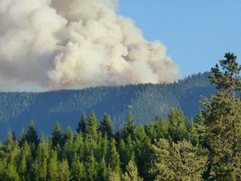
Smoke from the South Cle Elum Fire as seen from South Cle Elum Rail Yard on Sunday, Aug. 10, 2014. Jana Stoner photo
Incident: South Cle Elum Ridge Fire Wildfire
Released: 2 hrs. ago
The fire is very active on all fronts this afternoon and putting up a lot of smoke. The VLAT (Very Large Airtanker) has made 3 retardant drops already and will return to make additional drops as needed. As of 2:30 P.M. the fire had not crested the South Cle Elum Ridge Fire. As of 2:00 P.M. the fire remained south of the South Cle Elum Ridge. Around 1:00 PM firefighters working on the line, ordered retardant drops to prevent the fire from moving beyond established firelines. Retardant cools and slows fire progress giving firefighters an opportunity to get in and to maintain or construct line.
============================
Update Aug. 11, 2014 12:30 p.m.
DNR bans all outdoor burning: Those who start or spread fires subject to civil and criminal penalties
OLYMPIA – With dangerously hot and dry weather driving fire danger to a new high, the Washington State Department of Natural Resources (DNR) is expanding the current statewide burn ban to cover all outdoor burning on all DNR-protected lands, with no exceptions, the agency announced today.
“All indicators are that we’ll continue to have high heat, low humidity, and storm systems with winds and lightning. That means huge potential for wildfires,” said Commissioner of Public Lands Peter Goldmark. “We need to do everything we can to minimize danger to people, homes and habitat.”
Hot and dry conditions since early summer have caused very high fire hazard conditions throughout the state. These conditions have caused fires to spread rapidly and challenged firefighting efforts. More than $91 million has been spent so far battling wildfires in 2014, and more than 350,000 acres have burned across the state. There are many weeks to go in this year’s fire season, which usually runs into October.
All outdoor burning on DNR-protected lands is prohibited under this ban, including recreational fires in campgrounds or anywhere on DNR-protected lands. Fireworks and incendiary devices, such as exploding targets, sky lanterns, or tracer ammunition, are illegal on all DNR-protected lands. Charcoal briquettes are also not allowed.
In addition, DNR urges extreme caution around any activity that may cause a fire to start. Under these severe fire-hazard conditions, logging operations, land clearing, road and utility right-of-way maintenance, use of spark-emitting equipment, and other activities that create a high risk of fire ignition should be drastically curtailed.
Those who negligently allow fire to spread or who knowingly place forestlands in danger of destruction or damage are subject to possible civil liabilities and criminal penalties under state law. DNR, as well as anyone harmed by such a fire, may pursue damages that include loss of property and fire suppression costs.
The statewide burn ban will run through September 30, 2014. It applies to all lands under DNR fire protection, which does not include federally owned lands.
======================
Update Aug. 11, 2014 12:05 p.m.
The Kittitas County Public Health Department Recommends Cancelling Outdoor Activity for Poor Air Quality
As of 7:00 am today, the air quality in Kittitas County is considered very unhealthy. The Kittitas County Public Health Department (KCPHD) recommends outdoor activities be cancelled during times when air quality is “very unhealthy” or “hazardous” according to the Washington State Department of Ecology air quality monitoring site in Ellensburg.
Please check current air quality conditions. Air monitoring can be seen on the Washington State Department of Ecology air monitoring site: https://fortress.wa.gov/ecy/enviwa/
KCPHD will continue to update information on the Kittitas County Website at https://www.co.kittitas.wa.us/. For more information about health concerns relating to air quality or informational resources, please contact KCPHD at (509)-962-7515.
=============================
Update Aug. 11, 2014 10:15 a.m.
The Cle Elum area is under a Red Flag Warning from noon Monday until 5 pm Wednesday
Dozer constructing fire line by the South Cle Elum Ridge fire 8-11-14. Photo by Tim Foss
Yesterday (Aug. 10): In the afternoon, two spot fires started to the southwest of the main fire. Firefighters worked late into the night and made good progress halting the growth of those spot fires. Crews did some burnout operations along the north flank to strengthen the line and were able to put an initial dozer line down the east side of the fire. Firefighting resources continue to arrive, the number of personnel working on the fire more than doubled over the last 24-hours.
Today: A red flag warning has been issued for the Cle Elum area for dry and unstable conditions followed by thunderstorms with lightning. Given the weather conditions, expect to see smoke from active afternoon burning on the fire. On the north flank of the fire near the top of South Cle Elum Ridge, firefighters will work on strengthening and holding the line preventing fire spread to the north. Crews will also be working on getting dozer and handlines in on the east, west and south flanks. Helicopters and air tankers will continue to support firefighters on the ground as needed.
Evacuation Information: No change in evacuation levels. There continues to be a Level I evacuation advisement for the 15 homes over a mile away from the fire on the Woods and Steele Road.
Forest Closures: For public and firefighter safety the Okanogan-Wenatchee National Forest has issued an Area Closure in the Taneum Creek Area. Road blocks are in place on Forest Road 4510 (Woods and Steele Road), junction of Forest Roads 3352 and 119 (Five Corners) and Forest Road 3300 at the Bridge across the South Fork Taneum Creek.
Due to very high fire danger a campfire ban has been in place on the Okanogan-Wentachee National Forest since July 18th. It is extremely important that forest visitors and campers continue to cooperate and support local firefighting efforts by having no campfires.
Weather Outlook: Monday will be hot and dry. There is a chance of scattered thunderstorms Monday night. Light winds are predicted to be out of the northeast during the day with the possibility of gusty erratic winds near thunderstorms in the evening.
For area closure information contact: Cle Elum Ranger District: 509.852.1100 Monday through Friday 8-4:30pm.
Cooperating Agencies: The Okanogan-Wenatchee National Forest, Washington State Department of Natural Resources, Kittitas County Fire Districts 7 and 1, and Kittitas County Sheriff’s Office.
FIRE STATUS
- Acres Burned: 300 acre estimate
- Containment: 0%
- Structures Destroyed: 0
- Closures: Closure Area for Taneum Creek on Cle Elum Ranger District, Campfire Ban
- Cause: Lightning suspected; formal investigation pending
RESOURCES
- Crews: 7
- Engines: 22
- Dozers: 2
- Helicopters: 1
- Total personnel: 271
- Injuries: 0
=======================
Update Aug. 11, 2014 9:00 a.m.
Multiple Fires in Kittitas Causes Poor Air Quality – Sensitive populations are advised to limit outdoor activity
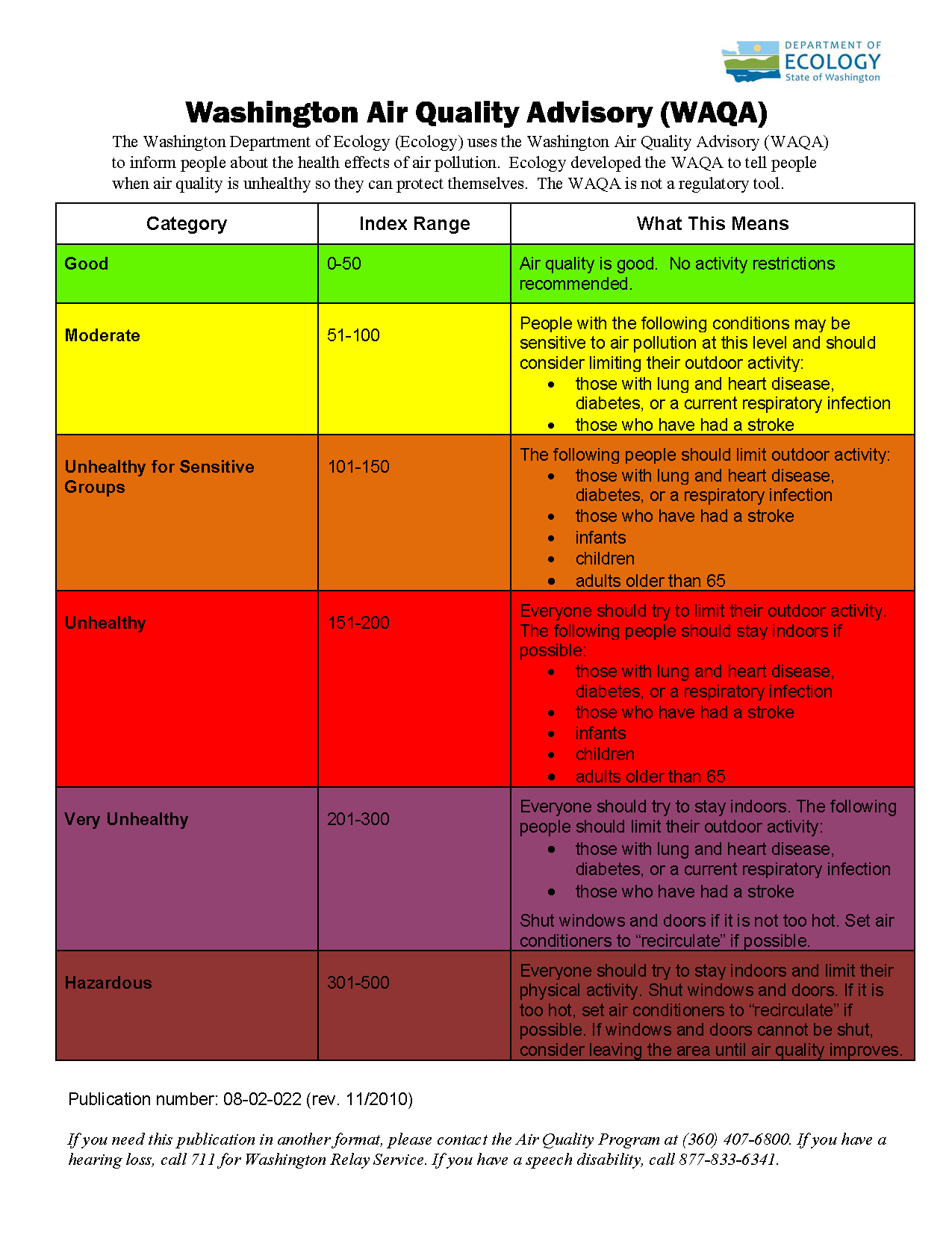
Washington Air Quality Levels Definitions. Click image for full size version.
Smoke from multiple fires in Kittitas County is causing poor air quality conditions. According to the Washington State Department of Ecology air quality monitoring site in Ellensburg, the air is “very unhealthy” as of 5:00 am today. The range of air quality categories include good, moderate, unhealthy for sensitive groups, unhealthy, very unhealthy, and hazardous. Air quality could continue to be poor while the fires burn.
During these conditions, everyone should try to limit their outdoor activity, avoid excessive exertion, avoid exposure to tobacco smoke or other respiratory irritants, and remain indoors with windows and doors closed. This recommendation is especially important for sensitive groups which include:
- People with pre-existing lung or heart conditions such as asthma or emphysema, diabetes, or other respiratory infections;
- People who have had a stroke;
- Infants, children, and adults older than 65; and
- Pregnant women.
Air conditioning units should be set on “recycle” or “recirculate” mode to reduce introduction of contaminated outdoor air. People without air conditioning need to take precautions against heat stress and should consider temporarily relocating to an area with better air quality such as a friend’s house, relative’s house, or a public space.
Adverse symptoms may include dizziness, headache, difficulty breathing, coughing, excessive phlegm, and nausea. Please contact your health care provider if you experience any of these symptoms.
Current air quality monitoring can be seen on the Washington State Department of Ecology air monitoring site: https://fortress.wa.gov/ecy/enviwa/
Information about health effects from wild fire smoke can be found on the Washington State Department of Health site: https://www.doh.wa.gov/CommunityandEnvironment/AirQuality/OutdoorAir/SmokeFromFires.aspx.
===========================
SUNDAY, AUGUST 10 |
Update Aug. 10, 2014 11:15 a.m.
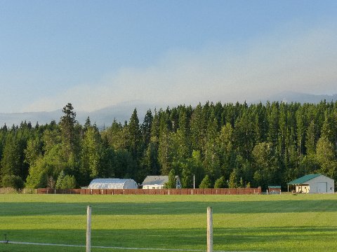
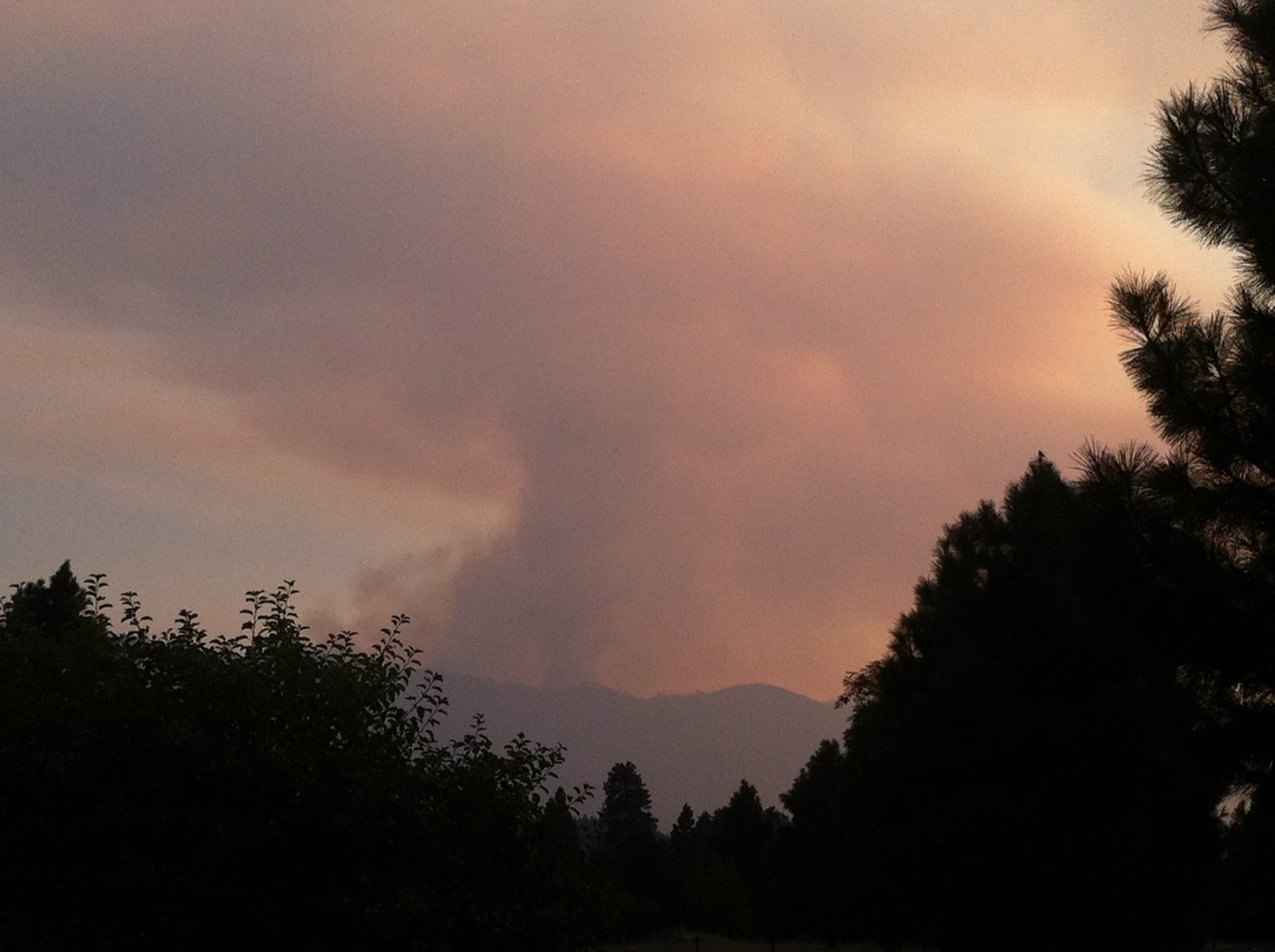
View of the smoke over the South Cle Elum Ridge Sunday, Aug. 10, 2014 (photo courtesy of Karen Watland.)
Crews remain successful in keeping fire away from communities
Current Situation: Firefighters continue to be successful in keeping the fire south of South Cle Elum Ridge and west of forest road 114. The fire has not had any significant growth and is estimated to be 300 acres in size. Today firefighters will continue to construct and strengthen indirect and contingency lines around the fire. Some areas are still unsafe for firefighters due to standing dead and burned trees. Deputy Incident Commander Jim Furlong expressed his appreciation this morning by saying, “I’d first like to acknowledge all the hard work the local initial attack fire crews have done to keep the fire on the south side of ridge, away from communities.” More crews have been ordered and are expected to arrive throughout the day. Helicopters and air tankers will continue to support firefighters on the ground as needed.
Evacuation Information: No change in evacuation levels. There continues to be a Level I evacuation for the 15 homes over a mile away from the fire on the Woods and Steele Road.
Forest Closures: For public and firefighter safety the Okanogan-Wenatchee National Forest has issued an Area Closure in the Taneum Creek Area. Road blocks are in place on Forest Road 4510 (Woods and Steele Road), junction of Forest Roads 3352 and 119 (Five Corners) and Forest Road 3300 at the Bridge across the South Fork Taneum Creek.
Due to very high fire danger a campfire ban has been in place on the Okanogan-Wentachee National Forest since July 18th. Yesterday evening an engine working on the South Cle Elum Ridge Fire was asked to respond to an escaped abandoned campfire on the Cle Elum Ranger Distirct. It is extremely important that forest visitors and campers continue to cooperate and support local firefighting efforts by having no campfires.
Weather Outlook: Winds will generally be light and terrain driven winds through Sunday morning then switch to the east and persist until Tuesday afternoon. There is a slight chance for dry thunderstorms Monday night with the chance increasing for Tuesday and Wednesday.
For area closure information contact:Cle Elum Ranger District: 509.852.1100 Monday through Friday 8-4:30pm.
Cooperating Agencies: The Okanogan-Wenatchee National Forest, Washington State Department of Natural Resources, Kittitas County Fire Districts 7 and 1, and Kittitas County Sheriff’s Office.
FIRE STATUS
Acres Burned: 300 acre estimate
Cause: unknown
Structures Destroyed: 0
Closures: Closure Area for Taneum Creek on Cle Elum Ranger District, Campfire Ban
Containment: 0%
RESOURCES
Crews: 1
Engines: 18
Dozers: 2
Water Tenders: 3
Helicopters: 1
Total personnel: 127
Injuries: 0
=========================
SATURDAY, AUGUST 9 |
Update Aug. 9, 2014 2:25 p.m.
 Current Fire Situation:
Smoke from the South Cle Elum Ridge Fire is visible from Interstate 90 and the Cle Elum vicinity. The fire was estimated Friday at approximately 400 acres. It is primarily burning in large timber on the Okanogan-Wenatchee National Forest, on the south side of South Cle Elum Ridge. The fire spotted, less than a quarter-mile to the east, on private timber land and Forest Service land. The nearest homes are over a mile away to the northeast, on the Woods and Steele Road. Fifteen residences on that road have been notified by the Kittitas County Sheriff’s Office to be aware of the fire situation in the area and make plans in case there becomes a need to evacuate. This is considered a Level 1 evacuation level, be “Ready” in case the fire situation changes.
Today, 3 crews and 5 engines from throughout the Okanogan-Wenatchee National Forest continue on their mission of keeping the fire south of Forest Road 4510 (at the top of the ridge), and west of the 114 Spur of the 4510 road. They will be supported by helicopters currently assigned to the nearby Snag Canyon fire if needed, and air tankers are available if called. More crews, engines, and a feller-buncher have been ordered to create fire line and stronger fuel breaks to contain the fire; these resources should arrive today and tomorrow.
Hotter temperatures and drier air are expected through the weekend. With the dry air and the very large trees and downed logs on the ground, the fire is expected to burn actively throughout the day. Winds are expected to be lighter today than previous days, and terrain-driven.
Safety is the Priority
Firefighter and public safety is the focus of all working on the fire, and that emphasis was shared by representatives from the Forest Service, Washington State Department of Natural Resources, and Kittitas County Fire Districts at the morning briefing for firefighters. The very steep slopes, large trees and dead standing trees (snags), and the narrow steep roads to access the fire are all concerns for fire personnel. To help keep firefighters and the public safe in the fire area, there are Forest Service road closures in place on Forest Road 4510 (Woods and Steele Road), junction of Forest Roads 3352 and 119 (Five Corners) and Forest Road 3300 at the Bridge across the South Fork Taneum Creek. The visibility of smoke along Interstate 90 is also a concern, and drivers are reminded to focus on the road even when smoke or air resources make interesting sights. Forest managers remind recreationists and other forest visitors that fire danger remains very high and there are still campfire restrictions in place throughout the Okanogan Wentachee National Forest. Smoke impact information, for this fire and others in central Washington, is available at wasmoke.blogspot.com
As of 6:00 this morning, Washington Interagency Incident Management Team 3 has been delegated responsibility for managing the fire, so local resources can be ready for initial attack if any new fires start. The Incident Command Post is being set up just west of Thorp at the Heart K Ranch.
Cooperators: The Okanogan-Wenatchee National Forest, Washington State Department of Natural Resources, Kittitas County Fire Districts 7 and 1, and Kittitas County Sheriff’s Office.
Basic Information
| Current as of | 8/9/2014, 12:48:01 PM |
|---|---|
| Incident Type | Wildfire |
| Date of Origin | Thursday August 07th, 2014 approx. 05:00 PM |
| Location | 6 miles southwest of South Cle Elum |
| Incident Commander | Bob Allbee |
Current Situation
| Total Personnel | 125 |
|---|---|
| Size | 400 Acres |
Current Weather
| Weather Concerns | Warming and drying trend expected Saturday through Monday |
|---|
===================================
FRIDAY, AUGUST 8 |
Update Aug. 8, 2014 4:45 p.m.
15 Homes Under Level 1 Evacuation Notice
The Kittitas County Emergency Operations Center continues to monitor the South Cle Elum Ridge Fire six miles south of Cle Elum.
In the South Cle Elum area, fifteen residences in the Woods and Steele Road area are currently under a Level 1 evacuation notice. For residents, this is the time for preparation and precautionary movement of persons with special needs, mobile property, and pets or livestock.
No homes are under a Level 2 or 3 evacuation notice for the South Cle Elum Ridge Fire at this time. A Level 2 notice advises residents to be prepared to leave at a moment’s notice. Under a Level 3 notice, residents are advised to evacuate immediately.
Residences affected by the fires can contact the EOC at 509-933-8305 for more information, or visit the county website for updates and evacuation maps at https://www.co.kittitas.wa.us/.
=================================
Update Aug. 8, 2014 3:45 p.m.
Despite Wildfires and Closures, Much of the Forest Is Still Open
Even though some wildfires remain uncontrolled and several area closures are in effect for public safety, large areas of the Okanogan-Wenatchee Forest remain open to recreation.
“Fires have burned across thousands of acres of this forest, and firefighters are still working to control some difficult fires in Okanogan, Chelan, and Kittitas Counties,” said Mike Balboni, Okanogan-Wenatchee Forest Supervisor. “But this is a very large National Forest, and several of our districts have been spared large fires so far this season,” he said.
Recreation still is in full swing on the Tonasket, Chelan, Cle Elum, and Naches Ranger Districts, he noted. Even the Methow Valley and Wenatchee River Ranger Districts, which have been dealing with some very large wildfires, still offer recreation opportunity in areas as yet unaffected by fire. The exception is the Entiat Ranger district, which is mostly blanketed with fire area closures and has all its campgrounds shut down.
Although much of the Methow Valley Ranger District is closed, the Highway 20 corridor west of Winthrop and the Forest Service campgrounds and trails in it are open to recreation. Businesses in Winthrop and Twisp are in the middle of the summer tourism season.
Lake Chelan and most of the forest and trails around it still are open to recreation, as are Lake Wenatchee and the White River and Chiwawa River drainages.
In Chelan County, Leavenworth and Chelan have occasionally been impacted by smoke from fires, but merchants in both communities are open for business.
The latest information on wildfires and public safety closures is available online at the forest web site, www.fs.usda.gov/okawen.
“There is a forest-wide ban on campfires,” Balboni noted. “With such dry conditions and so many wildfires, we simply can’t take a chance on any human-caused fires.”
Forest users can help by putting out any abandoned campfires they encounter, and by reporting any unmanned fires they see, he said.
=================================================
Update Aug. 8, 2014 3:26 p.m.
Report from the Incident Information System

Image courtesy of nwcg
Incident Overview
Smoke from the South Cle Elum Ridge Fire is visible from Interstate 90 and the Cle Elum vicinity. As of 2:00pm on Friday, August 8th the fire is estimated to be 400 acres. Approximately 50 personnel are currently assigned to the fire, with more resources arriving today. Air tankers have lined much of the fire with retardant, and helicopters are working to keep hotter areas of the fire in check. The top priority is to keep the fire south of South Cle Elum Ridge. At this time no structures are directly threatened. As a precaution, the Kittitas County Sherriff’s Department has issued a Level 1 Evacuation for 15 homes on the Woods and Steele Road. Residents there should be aware of the fire situation in the area. Detailed evacuation information for all fires in the county is available through the Kittitas County Emergency Operations Center, at 509-933-8305.
There are Forest Service road closures in place on Forest Road 4510 (Woods and Steele Road), junction of Forest Roads 3352 and 119 (Five Corners) and Forest Road 3300 at the Bridge across the South Fork Taneum Creek.
The fire was called in from an observer around 5pm on August 7, 2014. The fire is located approximately 6 miles southwest of the town of South Cle Elum, approximately 1 mile southeast of Hicks Butte.
In the first few hours the fire grew over 100 acres. Helicopter and air tankers supported the firefighters in trying to slow fire growth all through the evening on Thursday.
Additional resources from around the state, including a Type 2 Incident Management Team, are arriving to support the initial attack resources. An Incident Command Post is being set up just west of Thorp at the Heart K Ranch.
Fire managers are continuously monitoring the weather and fire behavior. A warming and drying trend is expected Saturday through Monday. Fire behavior has been active well into the night. Forest managers remind recreationists and other forest visitors that fire danger remains high and there are still campfire restrictions in place throughout the Okanogan Wentachee National Forest.
Basic Information
| Current as of | 8/8/2014, 2:51:30 PM |
|---|---|
| Incident Type | Wildfire |
| Date of Origin | Thursday August 07th, 2014 approx. 05:00 PM |
| Location | 6 miles South of South Cle Elum |
| Incident Commander | Kevin Mcphee |
Current Situation
| Total Personnel | 50 |
|---|---|
| Size | 400 Acres |
Additional information:
- 400 acres as of noon and the weather report they’re working with forecasts lightning events Monday and Tuesday.
- This is USFS Land at the present time.
- A Kittitas County Commissioner has been hired to act as the agency contact (DNR) for two
days this weekend, because DNR is short on resources and exhausted from long shifts. - The status is changing quickly and they’re shifting commands. We will report more as information becomes available.
======================
Important Update Aug. 8, 2014 – 12:00 p.m.
South Cle Elum Ridge Fire remains active
We have received a report from local sources that the fire is not fully contained, as reported earlier from the regional agency information. We are looking into this revised status, and will update this story as details become available.
=====================
UPDATE: Aug. 8, 2014 – 10:20 a.m. –
In their Morning Brief today, the Northwest Interagency Coordination Center reports that the fire which started yesterday, 10 miles SW of Cle Elum, is “fully contained.” [see update above]
Washington Interagency Management Team (WA IMT2) Team 3, under Incident Commander Bob Allbee, mobilized for the suppression efforts. The agency reports that 400 acres of timber, in steep terrain, was destroyed by the fire.
Karen Watland of Cle Elum chronicled the progress of the South Cle Elum Ridge Fire photographically. (Photo courtesy of Karen Watland, with permission)
Cle Elum area residents watched the smoke plume arising from behind Peoh Point with concern yesterday, awakening to relief at the clear skies this morning. Photographer Karen Watland of Cle Elum said this morning, “The planes were there pretty quick and did a great job of putting it out. Having the canal water so close helped the helicopters dumping water too. We are so thankful to such a great fire response crew. We could see flames from our house at around 7pm. Very little smoke remains this morning.”
===========================================
UPDATE: Aug. 8, 2014 – 12:08 a.m. –
This fire is on the heavily timbered land of the US Forest Service, South of the South Cle Elum Ridge between the 3300 Road and the 4510 Road. Sheriff’s Deputies have initiated a Level 1 Evacuation Notice for the homes off the Woods & Steele Road. Deputies are going door to door with a cautionary warning about the fire. No one is being advised to evacuate at this time. The Forest Service responded very quickly to this fire and, at their request, The Sheriff’s Office and Public Works Department have placed barricades closing the 4510 Road. An Incident Management Team is reported to have been requested, specific to this fire.The Sheriff’s Emergency Operations Center is now monitoring both the Snag Canyon Fire in Ellensburg and the South Cle Elum Ridge Fire. Should evacuation be necessary, the Red Cross will activate a shelter and the EOC will allocate resources to insure public safety and the protection of critical infrastructure. If you are a resident close to the active burn site or in the path of the smoke, Kittitas County Public Health asks that you limit your time outdoors in order to limit exposure to unhealthy or hazardous air quality. Stay inside, especially in air conditioning, or go where there is healthier air to breathe.
Smoke from wildfire contains gases and fine particles that can cause burning to the eyes. The gases and fine particles can also be inhaled deep into your lungs, which makes it harder to breathe and can worsen other health conditions like asthma, according to the Washington State Department of Health (DOH). N95 masks are available at KCPHD.
KCPHD will inform Kittitas County residents of future air quality issues as a result of the Fires. For more information about health concerns relating to air quality, informational resources, or N95 masks please contact KCPHD at (509)-962-7515.
========================================
THURSDAY, AUGUST 7 |
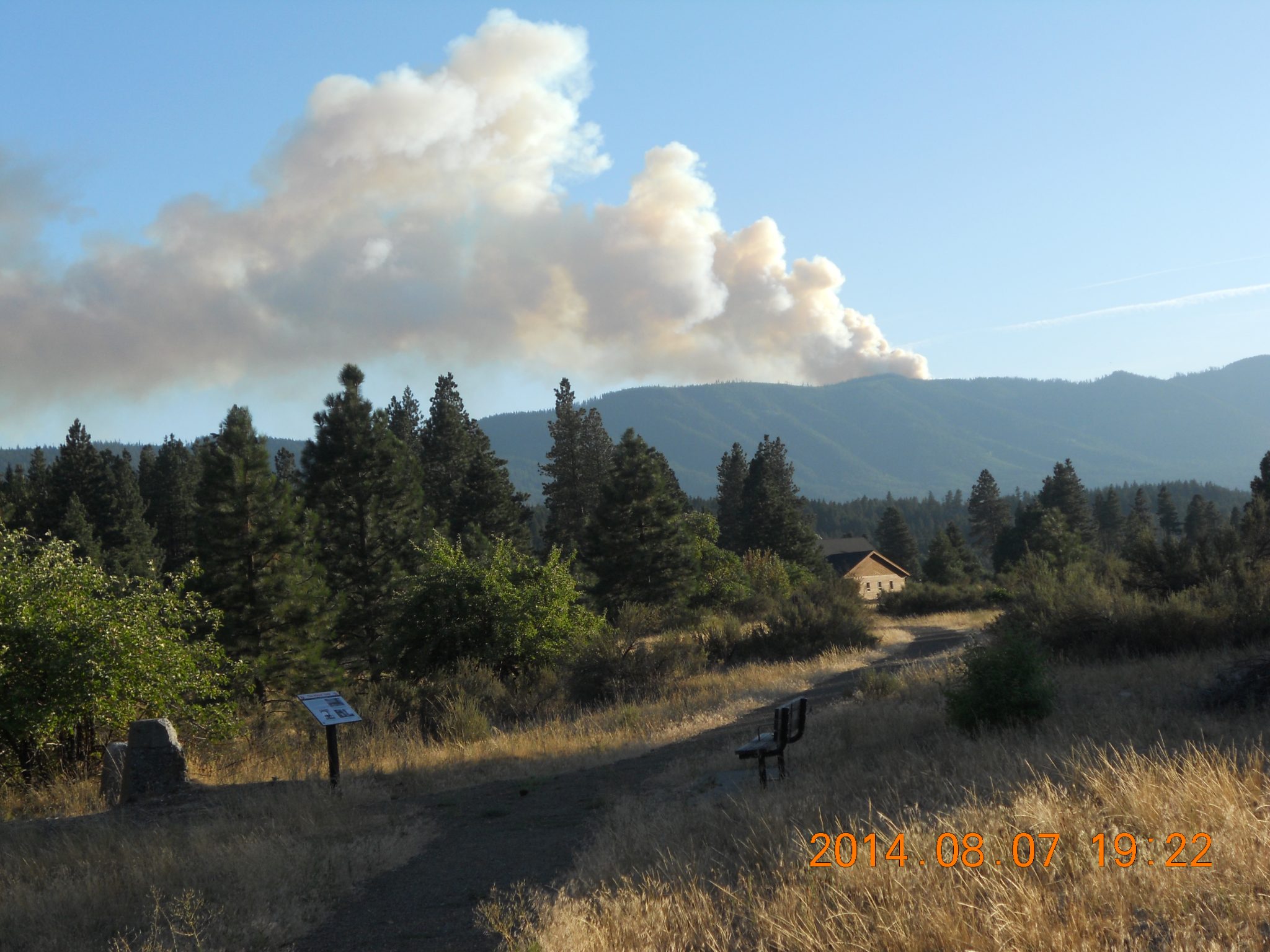
Photo courtesy of NKC Tribune reader Mary Pittis.
Aug. 7, 2014 – PEOH POINT – We have received early reports of a fire south and west of Peoh Point. Readers from Cle Elum, South Cle Elum, Easton and beyond are reporting a large plume of smoke emanating from behind the South Cle Elum ridgeline. Kittitas County Fire District #7 has posted to their Facebook page that this is currently a DNR – USFS fire, although they are monitoring the fire’s progress, with firefighters on standby. According to KCFD #7’s posting, “Wind blowing the fire East SE. (Out of NW). Air resources fighting with retardant drops and helicopters. Too much fire activity for ground force to engage according to radio traffic.” Will update as information becomes available.