
Updated 11:10 a.m. Thursday, Aug. 15, 2013 – County Roads to be Reopened at 12pm
Kittitas County, WA -08/15/2013 – Effective at 12pm today, the Kittitas County Sheriff’s Office will reopen all county roads affected by the Colockum Tarps Fire.
The 80,184-acre fire is now 98% contained. Some fire crews will continue working in the next several days on rehabilitation of areas impacted by fire suppression actions.
——————————————————
Updated 8:30 a.m. Tuesday, Aug. 13, 2013 – All Evacuation areas reduced to Level I
Though the evacuation levels have been reduced, the road closures will remain in place, and will be evaluated Thursday.
—————————————————–
Updated 9:30 a.m. Saturday, Aug. 10, 2013 –
Heavy lightning last night starts new fires, some more lightning expected today
Colockum Tarps Fire nearly contained; firefighters finishing mop-up and standing by to assist in new, nearby fire starts
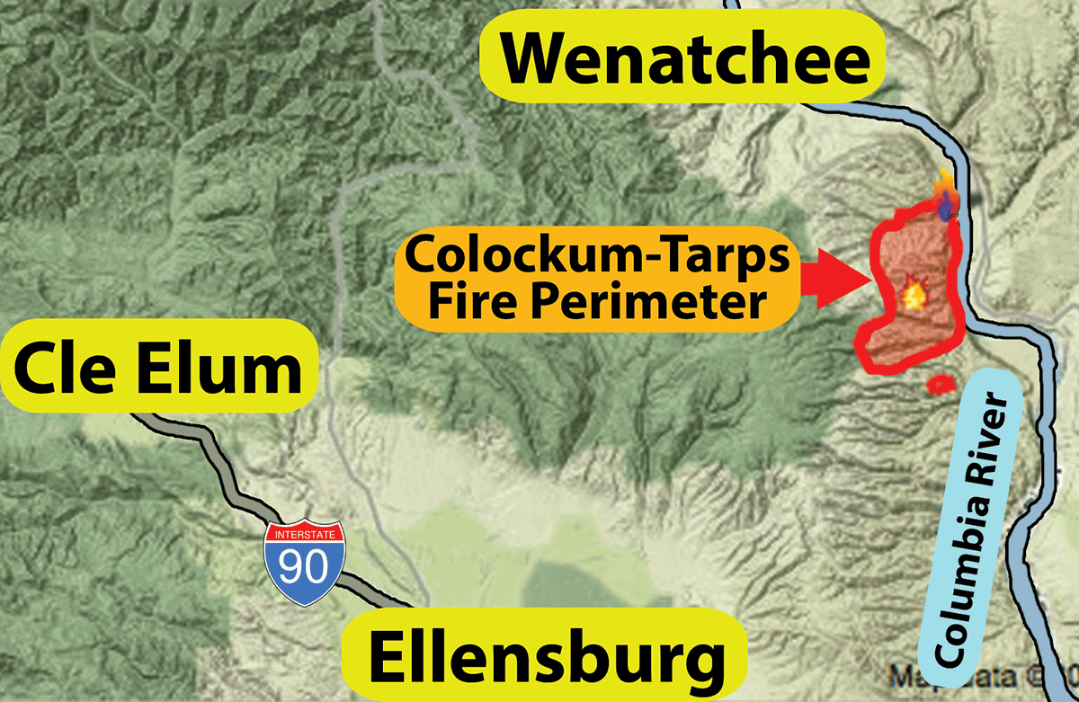
Wenatchee, Wash. – Firefighters were in the final phases of mopping up the burnout of the west perimeter of the 80,184-acre Colockum Tarps Fire yesterday when the predicted Red Flag Warning materialized last night, hitting southwest Washington and Cascades with lightning and increased wind. One lightning strike started a fire just north of the existing fire – west of the Columbia River and East of Kingsbury Road – that has now grown to approximately 1,400 acres (about two square miles).
Fire managers at the Colockum Tarps Fire are supporting the new, nearby fire with resources at the request of local, cooperators managing the new start. Initial attack resources, including dozers and engines, have mobilized to provide support. Incident meteorologists predict more lightning later today.
The Red Flag Warning was issued yesterday as the combination of dry fuels and incoming weather were predicted to be an aggravating factor to creating wildfires — be it dry humidity, lightning, and/or strong winds, that would help quickly spread any wildfire. In this particular case, today it’s lightning that is the biggest threat to starting new fires.
Light precipitation was received along the west perimeter of the two week-old Colockum Tarps Fire where burnouts had been conducted earlier this week. That perimeter has cooled down substantially, according to nightly infrared flights. Fuels are still burning throughout the interior of the fire, but these patchy, smoldering fuels and pockets of trees are not considered a threat to any of the established fire lines surrounding the fire area. The fire is 95 percent contained today. Firefighters are finishing mop-up in the Colockum Tarps Fire inside containment lines as crews and heavy equipment is being demobilized from the incident.
A Type III incident management team under the direction of Bob Marshall will assume authority for the Colockum Tarps Fire on Sunday, August 11, 2013 after a day of shadowing the current Washington Interagency Incident Management Team #4.
All Level 3 Evacuation areas near the Colockum Tarps Fire have been reduced to Level 2. Evacuation orders for the new fire north of the fire have not yet been determined. The map of Kittitas County current evacuation areas is available at https://tinyurl.com/jvz3x3u.
Many roads in the area, including the Naneum Road between “four corners” and the Colockum Road, continue to be closed. All current road closures will remain in effect through the weekend, with a reevaluation of these closures scheduled for Monday, August 12.
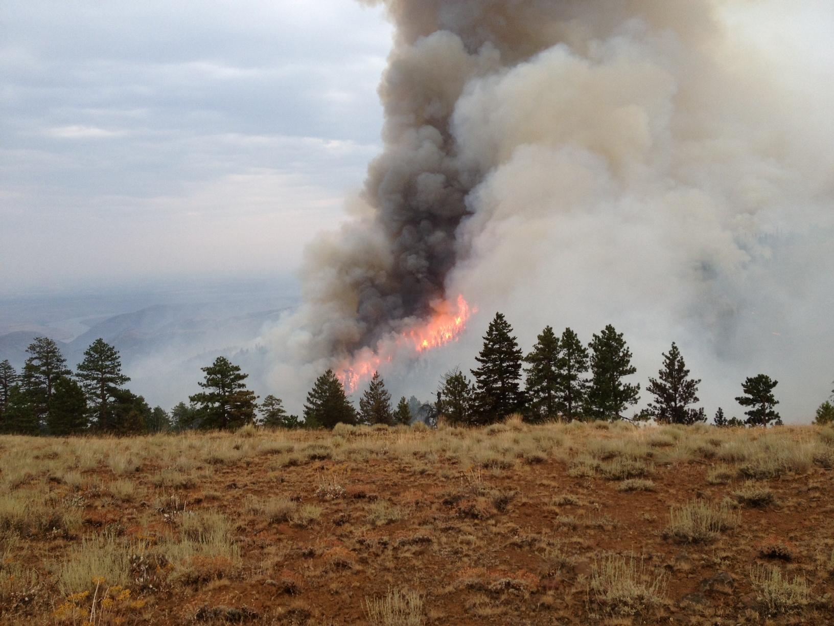
The Colockum Tarps Fire has been burning since Saturday, July 27, 2013, through dry grass, sagebrush and timber growing in steep drainages along the western shore of the Columbia River, 11 miles southwest of Wenatchee, Washington. It was human caused and grew rapidly.
Smoke rising from the interior of the fire may continue to be visible through August. A public information office is established in Ellensburg at the Washington Department of Natural Resources for concerns or questions about the fire at 509-925-0911.
Fire Facts – Saturday, August 10, 2013 –9:00 a.m.
- Fire Size: approximately 80,184 acresPercent Contained: 95%
- Evacuations: Levels 1 and 2 remain in effect in Kittitas and Chelan Counties. There are numerous road closures in the vicinity. In Kittitas County, sheltering is available for people or animals through the Red Cross as the need arises. Please contact the Emergency Operations Center at 509 933-8305 or KittCom at 509 925-8534.
- Fuels: Grass, brush, with timber at the higher elevations
- Air Resources: 2 Type I, 4 Type II, and 1 Type III.
- Crews: 2 Type I crews; 12 Type II crews
- Engines: 54
- Dozers: 3
- Water Tenders: 16
- Total Personnel: Approx. 649
- Cost to Date: $9.1 million
——————————————————–
Updated 9:30 a.m. Friday, Aug. 9, 2013 –
Last Section of Fire Perimeter Tied Together; Crews Continue Mop-up

Recycling made fun at base camp
Credit: Washington Interagency Incident Management Team #4
Wenatchee, Wash. – Firefighters joined the last sections of Division C and D together yesterday, burning interior ground fuels adjacent to established firelines and mopping up hot spots to tightly secure the perimeter of the 80,801-acre Colockum Tarps Fire. One of the most important parts of constructing a fire containment line is securely connecting sections together; and often the final sections to be joined involve the most challenging fuel or terrain. This has been true for the rocky, steep, timbered drainages along the western edge of the Colockum Tarps Fire.
Yesterday, temperatures approaching 80 degrees and lower relative humidity made for excellent burning conditions. Heavy fuels were consumed by burning operations within the fire perimeter. Air operations closely supported ground crews to contain fire throughout the day. The Fire is now 75% contained.
Interior of the perimeter, fire was active last night with occasional tree torching, but night-patrol crews report that it stayed within its intended “box.” Infrared devices have been used to identify areas of concentrated heat. Today, firefighters will continue to hold and mop up along firelines, closely monitoring fire behavior as easterly winds affect the area. Dozers and crews continue rehabilitating fire lines. Excess heavy equipment, crews, and aircraft are being demobilized and made available for other area fires.
Smoke may continue to be visible west of the Fire as winds pick up today from the east. Public information officers working at the incident command post in Wenatchee are available throughout the day to provide immediate updates about the fire to the public. Information about burning out and aerial ignition techniques can be found at https://tinyurl.com/lczmjsg.
A low pressure system, bringing the possibility of some precipitation, increasing winds with gusts up to 20 mph, and thunder storms with lightning is expected to arrive from the south tonight. A red flag warning for widespread thunderstorms from 5:00 p.m. until 11:00 p.m. has been issued.
A Type III incident management team under the direction of Bob Marshall will assume authority for the Colockum Tarps Fire on Sunday, August 11, 2013 after a day of shadowing the current Washington Interagency Incident Management Team #4.
As of 2:30 p.m. yesterday, as a result of successful firefighting operations, the Kittitas County Sheriff phased its Emergency Operations Center down to status with Enhanced Communications only. All Level 3 Evacuation areas are dropping to Level 2; otherwise, levels across the county remain in effect. All permanent residents have been able to return to their homes. Evacuation Level 2 or higher areas are only open to property owners and fire crews. The map of Kittitas County current evacuation areas is available at https://tinyurl.com/jvz3x3u.
Many roads in the area, including the Naneum Road between “four corners” and the Colockum Road, continue to be closed. All current road closures will remain in effect through the weekend, with a reevaluation of these closures scheduled for Monday, August 12.
The Colockum Tarps Fire has been burning since Saturday, July 27, 2013, through dry grass, sagebrush and timber growing in steep drainages along the western shore of the Columbia River, 11 miles southwest of Wenatchee, Washington. It was human caused and grew rapidly. On July 31, the push from easterly winds moved the fire toward sparsely populated areas along the Parke, Caribou and Colockum Roads in Kittitas County prompting additional evacuation notifications.
Fire Facts – Friday, August 9, 2013 – 9:00 a.m.
- Fire Size: approximately 80,801 acresPercent Contained: 75%
- Evacuations: Levels 1, 2 and 3 remain in effect in Kittitas and Chelan Counties. There are numerous road closures in the vicinity. In Kittitas County, sheltering is available for people or animals through the Red Cross as the need arises. Please contact the Emergency Operations Center at 509 933-8305 or KittCom at 509 925-8534.
- Fuels: Grass, brush, with timber at the higher elevations
- Air Resources: One light, one medium, and two heavy helicopters.
- Crews: 2 Type I crews; 12 Type II crews
- Engines: 54
- Dozers: 4
- Water Tenders: 16
- Total Personnel: Approx. 738
- Cost to Date: $8.5 million
———————————————————–
———————————————————–
Updated 8:30 a.m. Thursday, Aug. 8, 2013 –
Evacuation levels reduced – Kittitas County, WA – The Kittitas County Sheriff’s office announced that effective 6:00AM this morning the Level III Evacuation zone surounding the private properties in the North-East protions of Kititas County were reduced to Level II.
All of the people who have been out of their homes for these past two weeks can return to their property. The fire teams have completed the back-burn operations in the lines adjacent to the private lands between Cook Canyon and Park Creek, thus reducing the risk to the homes.
The road closures will remain in place through the weekend and will be re-evaluated on Monday.
————————————————————–
Updated 3:20 p.m. Wednesday, Aug. 7, 2013 – Colockum Tarps Fire – Kittitas County, WA – Effective at 6am on Thursday, the Kittitas County Sheriff’s Office expects to reduce the Level 3 Evacuation to a Level 2 for;
- Colockum Road
- Sheep Creek
- Trail Creek
- Tucker Creek
- Secret Canyon to the end of the paved road
These areas will be open to property owners and fire crews only. Residents are advised to use caution as they return home and keep the roads clear for fire apparatus moving through the area.
The Level 3 Evacuation remains in place for Secret Canyon beyond the paved road and upper Parke Creek Road, including Hilltop Lane.
All current road closures will remain in effect through the weekend, with a reevaluation of these closures scheduled for Monday, August 12th.
The fire team has been completing back burns and aerial ignitions on the western flank of the Colockum Tarps Fire, with more aerial drops expected today. Residents in the Kittitas Valley can expect to see more large smoke plumes to the north as this work is continued.
The Emergency Operations Center would like to acknowledge the frustrations and concerns of residents eager to return to their homes. The EOC and fire management team have communicated regularly regarding evacuation levels, and changes are made once all safety considerations are accounted for. Please contact the EOC if you have an urgent need to access your home.
Residents affected by the fire can contact the EOC with questions or concerns, at 509-933-8305, or visit the county website for updates and evacuation maps at https://www.co.kittitas.wa.us/. For fire information, please visit https://inciweb.org/incident/3567/, or contact the Colockum Tarps Fire at 509-662-9984.
————————————————————-
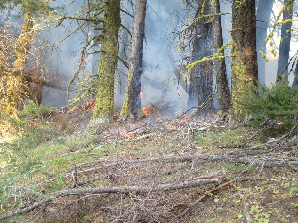
Updated 9:45 a.m. Wednesday, Aug. 7, 2013
Fuels dry out and burning out proceeds as weather heats up and humidity drops
Smoky scene adjacent to burn out operation
Credit: Washington Interagency Incident Management Team #4
Firefighters complete burnouts before aerial ignition begins in the final
stages of work to secure all perimeter fire lines at Colockum Tarps Fire
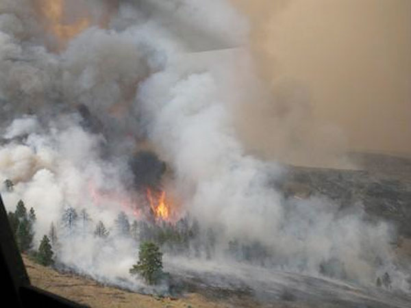
Wenatchee, Wash. – With the north, east, and south perimeters of the Colockum Tarps Fire cold and in varying stages of rehabilitation or mop-up, firefighters focused their attention yesterday on the last remaining containment line segments along the western flank where burnouts were conducted in preparation for aerial ignition of the 1,200-acre area at the head of Tarpiscan Drainage. Trees and fuels in the drainage are burning too close to the perimeter and fire managers feared torching trees could send the fire into unburned forest to the west. Firefighters have been waiting for several days to conduct the burnouts until humidity levels fell to a favorable level. With hot temperatures reaching 80 degrees yesterday, they finally got their chance. The humidity fell to 20 percent at 3,500 feet elevation.
Ignition of upper sections of Tarpiscan, Stray, Tekison and Brushy Creeks will continue today, finalizing the burning operation in the 80,400-acre fire. Evening winds out of the west and northwest have helped to keep the burnouts within the drainages where the fires are backing downhill through ground fuels. Occasional tree torching and short, quick runs are expected today and being closely monitored. Smoke from the burnouts was visible from Vantage, Kittitas and Wenatchee, Wash.
The burnouts below the fire lines will ensure the deeper aerial ignition does not escape the control lines in the future. Information about burning out and aerial ignition can be found at https://tinyurl.com/lczmjsg.
An equipment group has been organized at the satellite incident command post in Kittitas to manage and prioritize all of the heavy equipment being used at the fire, including dozers, water tenders and engines. Six helicopters are assisting firefighters with buckets of water where needed to cool down the burnout. There are 19 firefighting crews, most of whom are concentrated along the five-mile fire line being burned out. The fire is now 64 percent contained.
Steep, irregular terrain has made completion of fire line difficult along the western perimeter from the junction of Naneum and Colockum roads to Little Brushy Road. All other fire lines surrounding the Colockum Tarps Fire have been reinforced and mopped up. Once the burnout is complete and the threat to the perimeter control lines is reduced, containment may be achieved.
Evacuation levels are reassessed daily considering the condition of fire lines, threat from the fire, and the the capacity to notify residents of changing conditions. Although some evacuation levels have changed in Kittitas County, Level 3 Evacuations remain in place for the upper Parke Creek, upper Colockum and Secret Canyon areas, including Hilltop, Sheep Creek, Trail Creek and Tucker Creek. A map of Kittitas County evacuation areas is available at https://tinyurl.com/jvz3x3u. The Level 1 Evacuation Notification is still in effect for vicinities accessed by Colockum Road, Tarpiscan Road, and Kingsbury Road in Chelan County. The Colockum Road is closed in Kittitas County.
The Colockum Tarps Fire has been burning since Saturday, July 27, 2013, through dry grass, sagebrush and timber growing in steep drainages along the western shore of the Columbia River, 11 miles southwest of Wenatchee, Washington. It was human caused. On July 31, the push from easterly winds moved the fire toward sparsely populated areas along the Parke, Caribou and Colockum Roads in Kittitas County where a Level 3 evacuation notice was issued. The current major operational focus is to complete and reinforce containment lines through timber along the western edge of the fire.
Fire Facts – Wednesday, August 7, 2013 – 9:00 a.m.
- Fire Size: approximately 80,400 acres
- Percent Contained: 64%
- Evacuations: In effect in Kittitas and Chelan Counties. There are numerous road closures in the vicinity. In Kittitas County, sheltering is available for people or animals through the Red Cross as the need arises. Please contact the Emergency Operations Center at 509 933-8305 or KittCom at 509 925-8534.
- Fuels: Grass, brush, with timber at the higher elevations
- Air Resources: One light, three medium, and two heavy helicopters.
- Crews: 2 Type I crews; 17 Type II crews
- Engines: 53
- Dozers: 4
- Water Tenders: 16
- Total Personnel: Approx. 748
- Cost to Date: $7.2 million
————————————————————
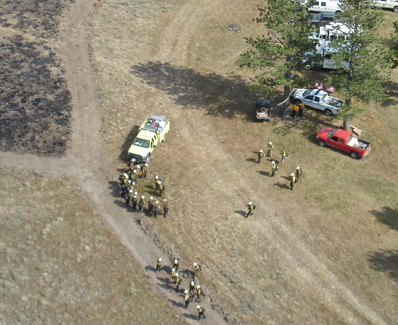
Updated 8:30 a.m. Tuesday, Aug. 6, 2013 – Wenatchee, Wash. – Fire managers found a window of opportunity yesterday afternoon to initiate burn-out operations in Division C on the west flank of the Colockum Tarps Fire.
The Goal Of Burnout Operations Is To Reduce Fuel Loads Next To Established Firelines.
Credit: Washington Interagency Incident Management Team #4
Relative humidity dropped enough for a successful test burn. Fire crews then started igniting along prepared, reinforced firelines to remove unburned ground fuels and create a blackened strip. The burned area was patrolled by crews throughout the night.
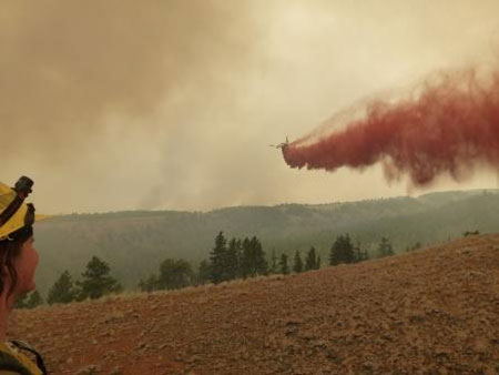
Today firefighters are expected to continue burnout along the west fire perimeter to create a continuous broad buffer. Once the blackened line area is sufficiently wide and cool, burnout of more interior fuels will proceed using aerial ignition techniques. Aerial ignition uses ping-pong-ball-like spheres filled with chemicals that, once ejected from an aircraft, ignite after hitting the ground. The spheres are spread in pattern intended to burn out large areas yet avoid undue damage. Aerial application is useful for burning out areas too steep or inaccessible for firefighters to safely enter. Aerial ignition is likely to be implemented within the next 36 hours when the reinforced fireline is ready and weather conditions are right to obtain the intended result.
Crews, water tenders, and helicopters are monitoring and patrolling fire activity during burnout procedures to prevent fire from breaching the established containment line.
Firefighters continued to construct direct fire line, burn out fine fuels to reinforce the line, and extinguish hot spots in Division D, also part of the western perimeter.
Line construction, mop up and rehabilitation along the northern and southern perimeters are nearly complete. Crews continue to patrol those areas. The fire is 60 percent contained.
Today, ridge top winds will be 4 to 7 miles per hour with humidity expected to drop to 30 to 35 percent. Warmer, drier weather with temperatures reaching 80 degrees on the fireline is expected to increase fire activity. The public can expect to see an increase in smoke being released from interior burning and purposeful burnout activities near containment lines.
Although some evacuation levels have changed in Kittitas County, Level 3 Evacuations remain in place for the upper Parke Creek, upper Colockum and Secret Canyon areas, including Hilltop, Sheep Creek, Trail Creek and Tucker Creek. A map of Kittitas County evacuation areas is available at https://tinyurl.com/jvz3x3u. The Level 1 Evacuation Notification is still in effect for vicinities accessed by Colockum Road, Tarpiscan Road, and Kingsbury Road in Chelan County. The Colockum Road is closed in Kittitas County.
The Colockum Tarps Fire has been burning since Saturday, July 27, 2013, through dry grass, sagebrush and timber growing in steep drainages along the western shore of the Columbia River, 11 miles southwest of Wenatchee, Washington. It was human caused. On July 31, the push from easterly winds moved the fire toward sparsely populated areas along the Parke, Caribou and Colockum Roads in Kittitas County where a Level 3 evacuation notice was issued. The current major operational focus is to complete and reinforce containment lines through timber along the western edge of the fire.
Fire Facts – Tuesday, August 6, 2013 – 9:00 a.m.
Fire Size: approximately 80,400 acres
Percent Contained: 60%
Evacuations: In effect in Kittitas and Chelan Counties. There are numerous road closures in the vicinity. Some evacuation levels have changed. For updates visit the Kittitas County Interactive Web Map: https://tinyurl.com/jvz3x3u In Kittitas County, sheltering is available for people or animals through the Red Cross as the need arises. Please contact the Emergency Operations Center at 509-933-8305.
Fuels: Grass, brush, with timber at the higher elevations
Air Resources: One light, one medium, and two heavy helicopters.
Crews: 2 Type 1 crews; 19 Type 2 crews
Engines: 53
Dozers: 8
Water Tenders: 16
Total Personnel: Approx. 810
Cost to Date: $6.5 million
Colockum Tarps Fire Information
Washington Interagency Incident Management Team #4
509-662-9984
https://inciweb.nwcg.gov/incident/3567
———————————————————
Updated 4:00 p.m. Monday, Aug. 5, 2013 – Kittitas County, WA – The Kittitas County Sheriff’s Office has lowered evacuation levels in some areas affected by the Colockum Tarps Fire:
- The Wild Horse Wind Farm has been reduced to Level 2 from Vantage Highway to the Renewable Energy Visitor Center. Beacon Ridge Road remains closed north of the Visitor Center.
- Parke Creek Road south of the Little Parke Creek junction is also now a Level 2.
- Cooke Canyon is now at a Level 1 advisory, as are residences on the north side of Vantage Highway east of the Operating Engineers’ Training Facility to the wind farm boundary.
- The western shoreline of the Columbia River from the northern Kittitas County line south to Skookumchuck Creek and Scammon Landing are now at Level 1 advisory. The area is closed to the public.
- The evacuation levels have not been changed in some areas. Level 3 Evacuations remain in place for the upper Parke Creek, upper Colockum and Secret Canyon areas, including Hilltop, Sheep Creek, Trail Creek and Tucker Creek.
Fire crews continue to connect and reinforce a challenging two-mile section of fire containment line in steep terrain from the Caribou Road to Powerline Road and Brewton Road across the forested canyons of Stray Creek, Tekison Creek and Little Brushy Creek. The fire danger is still significant until a solid perimeter is established.
Residents can expect to see firefighting equipment and personnel in the vicinity of the fire as the incident management team stages equipment and personnel in strategic locations for efficient access to address changing needs. Several crews work the night shift when conditions are more favorable for firefighting efforts or to complete a specific project that extends beyond a single day’s shift.
Please continue to be aware of the potential for firefighting vehicle traffic, equipment and personnel working and maneuvering along narrow roads.
The Emergency Operations Center would like to thank the public for their continuous support and patience during this fire. The EOC continues to work closely with the fire management team to determine when it will be safe for residents to return home. There have been no reported injuries or major structure losses in Kittitas County. Please contact the EOC if you have an urgent need to access your home. Officials will attempt to resolve that problem if safety considerations permit.
The Red Cross emergency shelter remains open at the Mercer Creek Church, 1407 N. B Street, Ellensburg, for any evacuated residents.
Residents affected by the fire can contact the EOC with questions or concerns, at 509-933-8305, or visit the county website for updates and evacuation maps at https://www.co.kittitas.wa.us/. For fire information, please visit https://inciweb.org/incident/3567/, or contact the Colockum Tarps Fire at 509-662-9984.
———————————————————-
Updated 10:05 a.m. Monday, Aug. 5, 2013 –
Firefighters waiting for fine fuels to dry out, humidity to drop before conducting burn-out operations inside the west perimeter of the Colockum Tarps Fire
August 4, 2013. Containment Strategies Include Connecting And Reinforcing Fire Line On Western Perimeter Of Fire.
Credit: Washington Interagency Incident Management Team #4
Wenatchee, Wash. – More firefighting crews have arrived at the 80,400-acre Colockum Tarps Fire to help prepare for planned aerial and ground ignition of unburned fuels inside the west perimeter of the Fire. Fire managers called off the burnout yesterday because fine fuels – grasses and small-sized forest litter – were too moist to carry a thorough fire. Firefighters tested ignition yesterday, which was unsuccessful. They will test again this afternoon when relative humidity is expected to drop 5-10 percent and temperatures increase.
Firefighters will conduct a test fire in Division C today. If the test fire is successful, they will begin burnout of the fire line. This burnout action improves the effectiveness of constructed fire lines by removing fuels inside the line for up to several hundred feet. Fire managers expect the ignition the area below these lines to burn up to the prepared, reinforced line and substantially reduce the potential for the fire to escape control lines in the future.
In Division D, firefighters will continue to construct direct fire line and anticipate only small areas along the line will need to be burned out.
Any structures or residences outside of the fire area will be protected during the burnout by firefighting crews standing by with engines. If the burnout is conducted today, additional strike teams of engines will be place to continue patrolling and mopping up during night shifts tonight. There are 20 firefighting crews assigned to the fire. The fire is 60 percent contained.
The last remaining fire line along the western fire perimeter is being completed today. Steep, irregular terrain has made completion of this line difficult. All other fire lines surrounding the Colockum Tarps Fire have been reinforced similarly by widening the line and mopping up (burning out fine fuels and extinguishing hot spots) inside them. Fifty percent of fire lines along the northern-most perimeter are presently rehabilitated.
The fire received a small amount of rain yesterday as isolated showers in the western divisions. Humidity levels ranged from 60 to 70 percent. Today, winds will be out of the northwest at 5 to 10 miles per hour and humidity is expected to drop to 35 percent. If the burnout activities are conducted, the public can expect to see an increase in smoke or a possible smoke column.
Evacuations remain in effect in Kittitas County. Level 3 evacuation status remains unchanged for the area west of the fire in Kittitas County where residents from approximately 45 structures are still evacuated. The area between the Vantage Highway and the Wild Horse Wind Farm Visitors Center has been reduced to Level 2. There is no longer any evacuation in effect along the Columbia River so the Vantage boat launch and parking area have reopened. A map of Kittitas County evacuation areas is available at https://tinyurl.com/jvz3x3u. The Level 1 Evacuation Notification is still in effect for vicinities accessed by Colockum Road, Tarpiscan Road, and Kingsbury Road in Chelan County. The Colockum Road is still closed in Kittitas County.
The Colockum Tarps Fire has been burning since Saturday, July 27, 2013, through dry grass, sagebrush and timber growing in steep drainages along the western shore of the Columbia River, 11 miles southwest of Wenatchee, Washington. On July 31, the push from easterly winds moved the fire toward sparsely populated areas along the Parke, Caribou and Colockum Roads in Kittitas County where a Level 3 evacuation notice was issued.
Fire Facts – Monday, August 5, 2013 – 9:00 a.m.
- Fire Size: approximately 80,400 acres Percent Contained: 60%
- Evacuations: In effect in Kittitas and Chelan Counties. There are numerous road closures in the vicinity. In Kittitas County, sheltering is available for people or animals through the Red Cross as the need arises. Please contact the Emergency Operations Center at 509 933-8305 or KittCom at 509 925-8534.
- Fuels: Grass, brush, with timber at the higher elevations
- Air Resources: One light, one medium, and one heavy helicopter.
- Crews: 3 Type I crews; 17 Type II crews
- Engines: 59 Dozers: 9 Water Tenders: 15
- Total Personnel: Approx. 749
- Cost to Date: $5.8 million
——————————————————-
Updated 9:30 a.m. Sunday, Aug. 4, 2013 –
Fire fighters continue building and improving lines to surround the Colockum Tarps Fire; if conditions allow, may start burn-out operations today.
Wenatchee, Wash. – Firefighting crews continued working hard to complete fire lines along the western perimeter of the Colockum Tarps Fire. They are making good progress in the steep, timbered draws along that flank of the fire. The remaining four and one half (4.5) miles of fire line construction require careful preparation in order to successfully burn out remaining fuels and secure the line.
Fire managers say that once the last segments of line are connected, weather conditions will determine how quickly crews can fully implement burn-out of the heavy fuels along the line and within the steep, forested canyons inside of the fire perimeter. Drier conditions are needed before these ground and aerial ignition operations can start. High relative humidity near 70 percent at the burn area will not allow for a clean, thorough reduction of fuels.

Smoke Plume Dominates Skyline Above Wind Mills
Credit: Washington Interagency Incident Management Team #4
The 80,400-acre fire is now 60 percent contained. Two strike teams of engines will continue patrolling and mopping up during night shifts tonight.
Because of increasing temperatures and concern about the potential spread of the fire outside fire lines, evacuation levels for Kittitas County remain in effect. Level 3 evacuation status levels remain unchanged for the area west of the fire in Kittitas County where residents from approximately 45 structures are still evacuated. Level 1 Evacuation Notification is still in effect for vicinities accessed by Colockum Road, Tarpiscan Road, and Kingsbury Road in Chelan County. The Colockum Road is still closed in Kittitas County.
Firefighters continue work to rehabilitate hand and dozer-created fire lines along the northern-most and South Branch perimeters of the fire. Firefighters are mopping up the fire for the distance needed to provide containment inside all fire lines and 500 feet around structures.
High relative humidity, cooler temperatures, and cloud cover have kept fire activity at a minimum, the last couple of days. There is a slight chance of afternoon thunderstorms today and temperatures are predicted to climb early this week, increasing the potential for active fire behavior. Line establishment and reinforcement activities, including burn-outs, will help to make sure the fire stays within established perimeters.
The Colockum Tarps Fire has been burning since Saturday, July 27, 2013, through dry grass, sagebrush and timber growing in steep drainages along the western shore of the Columbia River, 11 miles southwest of Wenatchee, Washington. On July 31, the push from easterly winds moved the fire toward sparsely populated areas along the Parke, Caribou and Colockum Roads in Kittitas County where a Level 3 evacuation notice was issued.
Fire Facts – Sunday, August 4, 2013 – 9:00 a.m.
- Fire Size: approximately 80,400 acres
- Percent Contained: 60%
- Evacuations: In effect in Kittitas and Chelan Counties. There are numerous road closures in the vicinity. The Red Cross Shelter is located at Mercer Creek Church, 1407 North E Street, Ellensburg, Wash. An animal shelter is available at the Kittitas Valley Event Center. For more information contact the Kittitas County Emergency Operations Center 509 933-8305.
- Fuels: Grass, brush, with timber at the higher elevations
- Air Resources: One light, one medium, and two heavy helicopters.
- Crews: 3 Type I crews; 8 Type II crews
- Engines: 71
- Dozers: 8
- Water Tenders: 13
- Total Personnel: Approx. 780
- Cost to Date: $5 million
Colockum Tarps Fire InformationWashington Interagency Incident Management Team #4
Updated 4:00 p.m. Saturday, Aug. 3, 2013 – Kittitas County, WA – Evacuation Levels remain the same for Colockum Rd and upper Parke Creek Rd.
The Kittitas County Sheriff’s Office advises the Level 3 Evacuations will remain in place for the upper Parke Creek, upper Colockum and Secret Canyon areas today. The Sheriff’s Office is working with the fire team to evaluate these areas and determine when it is safe for residents to return home. Fire crews are attempting to back burn the areas at the end of Parke Creek Rd to the Power Line Road off of Colockum Rd. Easterly winds and steep canyons and draws are making the progression slow and difficult.
There have been no reports of structure loss in the evacuated areas at this time.
The Red Cross emergency shelter and the animal shelter at the Fairgrounds are on stand by and will be available if the need arises. Anyone from the evacuation zone needing either shelter should call the Emergency Operations Center at 509-933-8305 or Kittcom at 509-925-8534.
The fire team has set up a satellite camp at Kittitas Elementary School in Kittitas with about 400 firefighters and support personnel. The public can expect increased vehicle traffic for the duration of the fire, with the heaviest traffic in Kittitas during the hours of 7:00am-8:00am and 7:00pm-8:00pm, when fire crews are departing and returning.
As residents return to their homes, they may find their properties in disarray from fire protection measures that were put into place by fire crews in an effort to save structures. This includes but is not limited to cleared brush, displaced wood piles, and other combustible items moved away from structures. Kittitas Valley Fire & Rescue is offering assistance to any property owner within KVFR fire protection in the Cooke Canyon, Secret Canyon, Colockum and Parke Creek areas, when the evacuation order is lifted. Please contact Chief John Sinclair at 509-856-7714 or sinclairj@kvfr.org.
Residents affected by the fire can contact the EOC with questions or concerns, or visit the county website for updates and evacuation maps at https://www.co.kittitas.wa.us/. For fire information, please visit https://inciweb.org/incident/3567/, or contact the Colockum Tarps Fire at 509-662-9984.
————————————————————-
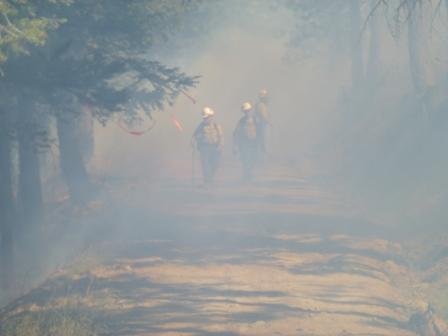
Updated 10:10 a.m. Saturday, Aug. 3, 2013 –
Firefighters will begin today burning out fuels inside fire lines to reduce fuels along west flank
Rough terrain, timber, and heavy fuels slow down construction of remaining fire line that will completely surround the Colockum Tarps Fire
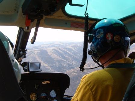
Helicopter Flight To Measure And Evaluate Situation On Colockum Tarps Wildfire
Credit: Washington Interagency Incident Management Team #4
Wenatchee, Wash. – Firefighting crews worked yesterday trying hard to complete the fire line along the western perimeter of the Colockum Tarps Fire. They did not complete it. Fire continues to burn in the steep, timbered draws along the western flank of the fire, requiring the burning out of fuels inside of the remaining three miles of fire line construction.
Fire managers say crews will continue working today and for 3-4 more days to complete the fire line in this last segment. The assignment requires reduction of heavy fuels inside the line within steep, forested draws along the top of ragged fire perimeter that encompasses the deep, timbered draws. Firefighters will be burning out fuels in the steep draws today and tomorrow in the Fire’s west flank divisions – Divisions C and D – using both ground and aerial ignition tactics.
Burn-out operations, including smoke and smoke columns may be visible from points throughout the Kittitas Valley for the next several days. Brian Gales, incident commander of the Washington Interagency Incident Management Team said today that the public should be aware that firefighters are using “fire to fight fire” and that the tactics being used are controlled and being executed to reduce the threat of spread of the fire to the west.
Once completed, the line will be reinforced and strengthened to keep the fire from moving westward from the steep draws to the Columbia River. The 80,400-acre fire is now 50 percent contained. Two strike teams of engines will continue patrolling and mopping up during night shifts tonight.
Because of increasing temperatures and concern about the potential spread of the fire outside fire lines, evacuation levels for Kittitas County will remain in effect. Evacuation status levels remain unchanged for the area west of the Fire in Kittitas County where residents from approximately 45 structures are still evacuated. The Level 2 Evacuation Notification affecting the Colockum Road, Tarpiscan Road, Kingsbury Road vicinity in Chelan County was reduced to Level 1 at noon yesterday. The Colockum Road is still closed in Kittitas County.
Firefighters have begun rehabilitating hand and dozer-created fire lines along the northern-most perimeter and several areas within the South Branch. Nearly 30 miles of fire line has been constructed along the north and west flanks of the fire. Firefighters are mopping up the fire for the distance needed to provide containment inside all fire lines and 500 feet around structures.
Slight winds out of the northwest most of Thursday and Friday kept the fire from moving out of the draws along the western flank of the fire. Sawyers and fallers worked to drop mistletoe-infected trees, snags and other large fuels to reduce the threat of them catching fire and spotting outside the lines. Trees have been torching at night in the draws.
High relative humidity, cooler temperatures, and cloud cover during the past two days have kept fire activity at a minimum, however with increasing temperatures predicted this week, the threat of increasing fire behavior and it escaping fire lines remains. Intermittent thunderstorms late Friday and this morning did not deliver much-needed moisture to the fire area. Light rains have not penetrated forest canopies and have not improved large forest fuel moisture recovery. Reconnaissance flights are still being made daily to patrol the entire fire area and locate flames and smoking fuels.
Washington State-mobilized resources are now being demobilized, with about 85 firefighters – primarily engine crews – to begin returning to their home units today. Remaining firefighters will continue to mop up, strengthen and secure fire lines, and patrol the fire. Most air support resources are now devoted to initial attack on new fire starts caused by lightning throughout the area, but are also available to ground crews if needed. Two strike teams of engines will continue patrolling and mopping up during night shift tonight.
A structure protection group is continuing to monitor and mop up around approximately 35 residences in the area surrounding Parke Creek Road. The residences were saved from burning by helicopter water and retardant drops followed by intensive ground effort late Wednesday.
The Colockum Tarps Fire has been burning since Saturday, July 27, 2013, through dry grass, sagebrush and sparse timber growing in steep drainages along the western shore of the Columbia River, 11 miles southwest of Wenatchee, Washington. The fire has spread quickly. On July 31, the push from easterly winds moved it toward sparsely populated areas along the Parke, Caribou and Colockum Roads in Kittitas County where a Level 3 evacuation notice was issued.
Fire Facts – Friday, August 3, 2013 – 9:00 a.m.
- Fire Size: approximately 80,400 acres
- Percent Contained: 50%
- Evacuations: In effect in Kittitas and Chelan Counties County. There are numerous road closures in the Fire vicinity. The Red Cross Shelter is located at Mercer Creek Church, 1407 North E Street, Ellensburg, Wash. An animal shelter is available at the Kittitas Valley Event Center. For more information contact the Kittitas County Emergency Operations Center 509 933-8305.
- Fuels: Grass, brush, with timber at the higher elevations
- Air Resources: One light, one medium, and two heavy helicopters.
- Crews: 4 Type I crews; 6 Type II Crews
- Engines: 89
- Dozers: 8
- Water Tenders: 17
- Total Personnel: Approx. 751
- Cost to Date: $4.3 million
Colockum Tarps Fire InformationWashington Interagency Incident Management Team #4
Updated 4:50 p.m. Friday, Aug. 2, 2013 – The Kittitas County Sheriff’s office announcement: The Level 3 Evacuations will remain in place for the upper Parke Creek, upper Colockum and Secret Canyon areas Friday night. The Sheriff’s Office is continuing to work with the fire team to evaluate these areas and determine when it is safe for residents to return home.
The Red Cross emergency shelter has been reopened at the Mercer Creek Church, 1407 N. B Street, Ellensburg, for any evacuated residents.
Residents affected by the fire can contact the EOC with questions or concerns, at 509-933-8305, or visit the county website for updates and evacuation maps at https://www.co.kittitas.wa.us/. For fire information, please visit https://inciweb.org/incident/3567/, or contact the Colockum Tarps Fire at 509-662-9984.
——————————————
Updated 2:00 p.m. Friday, Aug. 2, 2013 – Kittitas County, WA – The Kittitas County Sheriff’s Office advises the Level 3 Evacuations will remain in place for the upper Parke Creek, upper Colockum and Secret Canyon areas today. The Sheriff’s Office is working with the fire team to evaluate these areas and determine when it is safe for residents to return home.
There have been no reports of structure loss in the evacuated areas at this time.
The Red Cross emergency shelter and the animal shelter at the Fairgrounds are on stand by and will be available if the need arises. Anyone from the evacuation zone needing either shelter should call the Emergency Operations Center at 509-933-8305 or Kittcom at 509-925-8534.
Vantage boat launch has been reopened to the public.
The fire team has set up a satellite camp at Kittitas Elementary School in Kittitas with about 400 firefighters and support personnel. The public can expect increased vehicle traffic for the duration of the fire, with the heaviest traffic in Kittitas during the hours of 7:00am-8:00am and 7:00pm-8:00pm, when fire crews are departing and returning.
As residents return to their homes, they may find their properties in disarray from fire protection measures that were put into place by fire crews in an effort to save structures. This includes but is not limited to cleared brush, displaced wood piles, and other combustible items moved away from structures. Kittitas Valley Fire & Rescue is offering assistance to any property owner within KVFR fire protection in the Cooke Canyon, Secret Canyon, Colockum and Parke Creek areas, when the evacuation order is lifted. Please contact Chief John Sinclair at 509-856-7714 or sinclairj@kvfr.org.
Residents affected by the fire can contact the EOC with questions or concerns, or visit the county website for updates and evacuation maps at https://www.co.kittitas.wa.us/. For fire information, please visit https://www.co.kittitas.wa.us/, or contact the Colockum Tarps Fire at 509-662-9984.
—————————————————-
Updated 10:00 a.m. Friday, Aug. 2, 2013 – Firefighters working quickly to complete fire line around the Colockum Tarps Fire Today, while winds and humid weather still provide the window of opportunity
Smoke Arising From A Draw. Photo By Loretta Duke
Wenatchee, Wash. – Winds out of the northwest and about an eighth of an inch of precipitation over the Colockum Tarps Fire yesterday provided the conditions that allowed firefighters to construct about four miles of line along the most active, western perimeter. Firefighters, working alongside dozers, took advantage of the wind pushing the fire back into the black, and keeping the fire from spreading westward. Today, firefighters will address the approximately six miles remaining to complete line around the 80,108-acre fire. They will continue to mop up, establish, connect and secure fire lines and patrol the fire by ground and air. Air support resources will be devoted to initial attack on new fire starts caused by lightning throughout the area, but also available to ground crews if needed.
Isolated rain showers are expected today over the fire, and are expected to reduce extreme fire behavior in grass and light fuels, but not in trees and brush. Though rain is helping the firefighting efforts, it is also imposing additional safety hazards for firefighters including slick mud and loose rocks. Northwest winds will help push remaining fire back into the black, but upslope easterly winds will negate this benefit in some areas along the fire perimeter.
The Colockum Tarps Fire has been burning since Saturday, July 27, 2013, through dry grass, sagebrush and sparse timber growing in steep drainages along the western shore of the Columbia River, 11 miles southwest of Wenatchee, Washington. The fire has spread quickly. On July 31, the push from easterly winds moved it toward sparsely populated areas along the Parke, Caribou and Colockum Roads in Kittitas County. A Level 3 evacuation notice was issued to approximately 100 home-owners near the fire. Rapid response by air support resources late Wednesday, July 31, dropping retardant and water on the threatened homes, supported by ground forces, were successful. Only three small outhouses were lost.
Mike Asher, South Branch operations section chief, said that firefighter efforts yesterday to construct fire lines have “made all the difference” in stopping the Fire’s western advance.
“Nearly 300 firefighters worked hard to construct the strategic fire line at the most active portion of the fire,” Asher said. “As we continue to close up and reinforce the line today, we are aware of the risks of the fire spotting outside and spreading, and new lightning starts. We will continue to aggressively fight this fire,” he said.
Firefighters today will be wrapping up some of their work in the North Branch of the fire, with the most activity directed to the northwest divisions to burn out and cut off stringers of timber still burning in draws.
Dozers and fire crews have constructed more than 20 miles of fire line along the north and west flanks of the fire. The fire is now 30 percent contained. Firefighters are mopping up the fire 100 feet inside the fire lines and 500 feet around structures to ensure there is no heat remaining. Infrared heat-sensing devices and flights have also been used to locate hot fire undetected by the eye.
Strike teams of engines are patrolling and mopping up during night shifts. Helicopters, single engine airtankers (SEATs) and retardant planes are standing by to drop water and retardant to slow the spread of the fire and extinguish hot spots as needed, where visibility and weather allow during the day.
Approximately 60 people affected by the fire attended a public meeting held last night in Ellensburg, at Central Washington University. The meeting was organized by the Kittitas County Sheriff to provide information and support to citizens evacuated from their homes within the fire area or concerned about the fire spreading toward Ellensburg.
As of 12:00 today, the Level 2 Evacuation Notification affecting the Colockum Road, Tarpiscan Road, Kingsbury Road vicinity in Chelan County has been reduced to Level 1. The Colockum Road is still closed in Kittitas County.
Fire Facts – Friday, August 2, 2013 – 9:00 a.m.
- Fire Size: approximately 80,108 acres Percent Contained: 30%
- Evacuations: In effect in Kittitas and Chelan Counties County. Numerous road closures in the fire vicinity. Red Cross Shelter at Mercer Creek Church, 1407 North E Street, Ellensburg. An animal shelter is available at the Kittitas Valley Event Center. For more information contact the Kittitas County Emergency Operations Center 509 933-8305.
- Fuels: Grass, brush, with timber at the higher elevations
- Air Resources: One light, medium, and one heavy helicopter.
- Crews: 5 Type 1; 8 Type 2
- Engines: 90 Dozers: 7 Water Tenders: 15
- Total Personnel: Approx. 833
Colockum Tarps Fire Information
Washington Interagency Incident Management Team #4
509-662-9984
https://inciweb.nwcg.gov/incident/3567
————————————————————–
Updated 10:30 a.m. Thursday, Aug. 1, 2013 – Kittitas County, WA -08/01/2013 – The Kittitas County Sheriff’s Office advises the Level 3 Evacuations will remain in place for the next 24 hours for the upper Parke Creek, upper Colockum and Secret Canyon areas. The Sheriff’s Office is continually evaluating the evacuation levels as more fire information becomes available.
There are approximately 40-45 structures in the Level 3 Evacuation area, including primary residences and recreational properties. The Emergency Operations Center has confirmed no structures have been lost in Secret Canyon. Possible structure loss in other evacuated areas has not been determined at this time.
The Red Cross emergency shelter remains open at the Mercer Creek Church, 1407 N. B Street, Ellensburg. Anyone from the evacuation area who will be staying with family or friends, please provide contact information to the EOC at 509-933-8305 so we can provide you with updates.
The animal shelter is also still open at the Kittitas Valley Event Center. During regular business hours, 8:00am-5:00pm, anyone needing the animal shelter can check-in at the Western Town Ticket Center at Alder Street and 8th Avenue. Those needing assistance after business hours should call Kittcom at 509-925-8534.
A public meeting will be held on today at 6pm at Central Washington University’s Student Union Recreation Center, Ballroom B & C, second floor, 400 E. University Way, Ellensburg. Representatives from the Kittitas County Emergency Operations Center and the Washington Incident Management Team #4 will be present to give a fire update and answer questions. Parking is free.
Residents affected by the fire can contact the EOC during business hours, 8:00am-5:00pm, or Kittcom at 509-925-8534 during non-business hours, or visit the county website for updates and evacuation maps at https://www.co.kittitas.wa.us/. For fire information, please visit https://inciweb.org/incident/3567/, or contact the Colockum Tarps Fire at 509-662-9984.
———————–
Updated 9:00 a.m. Thursday, Aug. 1, 2013 – Wenatchee, Wash., Yesterday, consistent east winds pushed the fire upslope along the west shore of the Columbia River. As the fire moved toward populated areas, the Kittitas County Sheriff implemented Level 3 evacuations, notifying people in more than 100 homes to leave immediately. These people and their animals were offered shelter in Ellensburg, Wash.
Although firefighting efforts could continue in some areas, smoke filled the most actively burning section of the western flank, preventing aircraft from applying retardant or water. For several hours, it was also too dangerous for ground staff to engage the fire. When extreme conditions moderated, ground crews returned to point protection, supported by 14 aircraft.
Meanwhile, excellent progress was made improving the fire lines that are parallel to the wind direction. Dozers and elite fire crews constructed and widened firelines along the south and northwest flanks. Aided by long lines of retardant applied the night before, the fire front could not grow beyond those boundaries. Over the entire fire, containment has reached 25%.
A night shift was deployed for structure protection, line construction and patrolling the lines that are in place.
The priority of work today continues to be along the southern and western flanks to confine the fire. Significant resources have been assigned to those sections, with more crews and engines arriving today to help strengthen existing fire lines and construct new ones to close gaps. Hotshot crews intend to burn-out and enhance firelines in the upper part of the western flank. Strings of timber that have caught fire must be cut off so fire cannot continue moving uphill to the west. Dozers and hand crews are working along the south. Engines from around the state continue their assignment to protect homes and structures. Six helicopters, two single engine airtankers (SEATs) and two retardant planes are standing by to drop water and retardant to slow the spread of the fire and extinguish hot spots as needed, where visibility and weather allow.
All fire personnel continue to watch the weather closely. Steep canyons and the Columbia River can funnel and concentrate winds. The area is under Red Flag Warnings for thunderstorm activity with the potential for dry lightning until 11 p.m. tonight. Although lightning could start more fires, the larger concern is the erratic winds that come with thunder cells and push the fire in unpredictable directions.
A public meeting will occur at 6 p.m. tonight at Central Washington University’s Student Union Recreation Center Ballrooms B&C, second floor, 400 East University Way, Ellensburg.
People who are affected by smoke can obtain current air quality monitoring information is available online from the Washington State Department of Ecology at https://fortress.wa.gov/ecy/enviwa/.
Fire Facts – Thursday, August 1, 2013 – 9:00 a.m.
- Fire Size: approximately 72,000 acres Percent Contained: 25%
Evacuations: In effect in Kittitas and Chelan Counties County. Numerous road closures in the fire vicinity. Red Cross Shelter at Mercer Creek Church, 1407 North E Street, Ellensburg. An animal shelter is available at the Kittitas Valley Event Center. For more information contact the Kittitas County Emergency Operations Center 509
Fuels: Grass, brush, with timber at the higher elevations
Air Resources: One light, four medium, and one heavy helicopter. Two SEATs. Two air tankers. Two small air attack coordination planes.
Total Personnel: Approx. 700
Colockum Tarps Fire Information
Washington Interagency Incident Management Team #4
509-662-9984
https://inciweb.nwcg.gov/incident/3567
————————
Updated 7:30 a.m. Thursday, Aug. 1 – Evacuation Level lowered in Cook Canyon
Kittitas County, WA -08/01/2013 – The Sheriff’s Office lowered the Evacuation Level in Cook Canyon from Level III to Level II this morning at 6:30 AM.
Shifting winds, cooler temperatures and continued efforts from firefighters have allowed the residents in Cook Canyon to return to their homes this morning. The Colockum, Parke Creek, Secret Valley and Caribou Canyons are still closed. We do not have confirmation on any structural loss at this time. Additional information will be released as soon as it is available.
Please consult the Kittitas County Web Page https://wwwcall.co.kittitas.wa.us or call the Kittitas County Emergency Operations Center at 509-933-8305 for any specific questions or to report concerns.
——————–
Updated 2:00 p.m. Wednesday, July 31, 2013 – A good map for the evacuation zones can be found here.
Air Quality Fluctuates as Colockum Tarps Fire Continues to Burn
Current air quality monitoring can be seen on the Washington State Department of Ecology air monitoring site
When air quality conditions reach unhealthy for sensitive groups, people with asthma, respiratory infections, and lung or heart disease should limit time outdoors.
The Kittitas County Public Health Department will continue to inform Kittitas County residents of the air quality. “We cannot predict whether the county will eventually see unhealthy, very unhealthy, or hazardous air quality conditions,” stated Dr. Mark Larson, “since air quality depends on the wild fire situation and weather conditions. The most recent air quality report, according to the Washington Air Quality Advisory (WAQA), was moderate.”
Information about health effects from wild fire smoke can be found on the Washington State Department of Health site
——————————————————————
Updated 1:00 p.m. Wednesday, July 31, 2013 – Kittitas County, WA – The Kittitas County Emergency Operations Center has upgraded Level 1 and 2 Evacuation areas to Level 3 effective immediately due to increased movement of the Colockum Tarps Fire. (See Evacuations level map)
The following areas are now at a Level 3 notice and residents are advised to evacuate immediately:
- the area north of the intersection of Christensen Road
- Parke Creek Road, northwest to the intersection of Cooke Canyon Road
- Gage Road
- Cooke Canyon Road north of Gage Road
The Wild Horse Wind Farm is now closed to the public.
Also due to the fire spreading south, the Vantage boat launch and parking area are closed.
The EOC has issued a Level 2 Evacuation notice for:
- residences on the north side of Vantage Highway east of the Operating Engineers’ Training Facility to the wind farm boundary.
Residents are advised to be prepared to leave at a moment’s notice.
The Red Cross has opened an emergency shelter at the Mercer Creek Church, 1407 N. B Street, Ellensburg. We would ask that anyone from the evacuation area who will be staying with family or friends, please provide contact information to the EOC at 509-933-8305 so we can provide you with updates.
An animal shelter is also in place at the Kittitas Valley Event Center for anyone evacuating their animals. Check-in is located at the Western Town Ticket Center at Alder Street and 8th Avenue. If possible, please call the shelter prior to your arrival, 509-933-8399, to advise what type of animals and quantity you are bringing in.
Residents affected by the fire can contact the EOC during business hours, 8:00am-5:00pm, or Kittcom at 509-925-8534 during non-business hours. For fire information, please visit https://inciweb.org/incident/3567/, or contact the Colockum Tarps Fire at 509-662-9984.
—————————————————-
Updated 12:00 noon Wednesday, July 31 – Kittitas County, WA – The Kittitas County Sheriff’s Office has completed Level 3 Evacuation notifications for:
- the upper Parke Creek and
- Secret Canyon area
as the Colockum Tarps Fire continues to push southwest with shifting winds. Approximately 75 structures are in the Level 3 evacuation area, including 20-25 primary residences. The number of people displaced by the evacuations is unknown at the time.
The Emergency Operations Center has issued a Level 1 Evacuation advisement notice for:
- the area north of the intersection of Christensen Road
- Parke Creek Road, northwest to the intersection of Cooke Canyon Road
- Gage Road
- Cooke Canyon Road north of Gage Road.
Fire Retardant Application Using A Modified DC-10
Credit: Washington Interagency Incident Management Team #4
The public is strongly encouraged to monitor the County website for updates and evacuation maps at https://www.co.kittitas.wa.us/.
The Red Cross has opened an emergency shelter at the Mercer Creek Church, 1407 N. B Street, Ellensburg. We would ask that anyone from the evacuation area who will be staying with family or friends, please provide contact information to the EOC at 509-933-8305 so we can provide you with updates.
An animal shelter is also in place at the Kittitas Valley Event Center for anyone evacuating their animals. Check-in is located at the Western Town Ticket Center at Alder Street and 8th Avenue. If possible, please call the shelter prior to your arrival, 509-933-8399, to advise what type of animals and quantity you are bringing in.
At this time, no donations have been requested.
Residents affected by the fire can contact the EOC during business hours, 8:00am-5:00pm, or Kittcom at 509-925-8534 during non-business hours. For fire information, please visit https://inciweb.org/incident/3567/, or contact the Colockum Tarps Fire at 509-662-9984.
——————————————————–
Updated 9:15 a.m. Wednesday, July 31 – On Tuesday afternoon, crews responded to increased winds that pushed the fire to the south and west. Engine crews were redirected to help strengthen existing fire lines and construct new ones. Four helicopters, two single engine airtankers “SEATs” (scooper aircraft) and one large air tanker (a modified DC-10) were also used to drop water and retardant to slow the spread of the fire. Two Type 1 (Hotshot) crews worked to check the spread of the fire along the Bonneville Power line on the west side of the fire. One Type 1 crew was transported by boat across the Columbia River to construct line westward from the river. For the next few days an elite Washington DNR fire crew and these three hotshot crews will be camping close to their work areas. Fire officials are watching forecasted thunderstorm activity the next two days and the potential for dry lightning and erratic winds that could push the fire in many directions.
This morning, winds from the east at 5-10 miles per hour have been pushing the fire toward the west. This has elevated evacuations of residential areas to the west of the fire. See above.
On Tuesday afternoon, the Kittitas County Sheriff issued a Level 3 Evacuation Notification for:
- an area along the west side of the Columbia River from the county line to Scammon Landing and Skookcumchuck Creek.
The Chelan County Sheriff reduced the Level 3 Evacuation for areas north of the fire to a Level 2 ‘be ready to go’ pre-evacuation notification. Roads north of the fire are open for local use only and residents are cautioned to be on the lookout for heavy fire traffic in the area.
People who are affected by smoke can obtain current air quality monitoring information is available online from the WA State Department of Ecology at https://fortress.wa.gov/ecy/enviwa/.
Fire Facts – Wednesday, July 31, 2013 – 9:00 a.m.
- Fire Size: approximately 59,316 acres
- Percent Contained: 8%
- Evacuations: In effect in Kittitas and Chelan Counties County. Numerous road closures in the fire vicinity.
- Fuels: Grass, brush, with timber at the higher elevations
- Air Resources: One light, two medium, and one heavy helicopter. Two SEATs (scooper aircraft). Additional fire retardant drops on order.
- Firefighting Crews: Three Type 1 crews and six Type 1 crews
- Total Personnel: Approx. 400
- Engines: 15
- Dozers: 5
- Water Tenders: 5
——————————————–
Updated 4:45 p.m. Tuesday, July 30 – Kittitas County, WA – Effective 1:00 p.m. today, the Kittitas County Sheriff’s Office has upgraded the Emergency Operations Center (EOC) to Level 2 in order to activate additional EOC divisions and in preparation of the utilization of additional resources for the Colockum Tarps Fire. The Kittitas County Board of Commissioners declared a State of Emergency as of 2:15 today.
The fire continues to move south in Kittitas County and has grown to 52,000 acres as of 1000 this morning. There have no reports of structure loss in Kittitas County, and there is no imminent threat to residences at this point.

View From Helicopter July 29, 2013. Credit: Washington Interagency Incident Management Team #4
Due to the southern movement of the fire, the Sheriff’s Office has issued a Level 3 Evacuation notice from the northern Kittitas County line south to Skookumchuck Creek and Scammon Landing, along the western shoreline of the Columbia River.
The Columbia River is open to recreational activity, however, the Sheriff’s Office recommends boaters use extreme caution and be aware of helicopters in the area assisting in the firefighting efforts.
The Wild Horse Wind Farm is now under a Level 2 evacuation notice. The Renewable Energy Center is now closed to the public. Only property owners and authorized personnel supporting the firefighting efforts are allowed access through the wind farm.
The Level 2 Evacuation notifications remain in place for residences in the following areas:
- Colockum Pass Road north of the end of the pavement
- Trail Creek Road
- Sheep Creek Road
- Tucker Creek Road
- Secret Canyon Road
- Ryegrass Ranches Road
- Parke Creek Road north of the end of the pavement, including Hilltop Loop.
Under a Level 2 notice, residents should prepare to leave at a moment’s notice, as potentially dangerous conditions exist that may threaten residences.
A Level 1 Evacuation notice is now in effect for the Whiskey Wildlife Area as well.
The following roads remain closed to public access:
- Colockum Road at the end of the pavement
- Schnebly Canyon Road at the green gate (at the intersection of Fairview and Thomas Roads)
- Parke Creek Road at the end of the county road
- Coleman Canyon Road at the end of the county road
- Cooke Canyon Road at the end of the county road.
The Sheriff’s Office will assist the Department of Natural Resources and the Department of Fish and Wildlife with support and enforcement of road closures in these areas.
The smokey conditions throughout the county are expected to continue due to wind direction, and the Kittitas County Public Health Department continues to monitor air quality.
Residents affected by the fire can contact the Kittitas County Emergency Operations Center at 509-933-8305 during business hours, 8:00am-5:00pm, or Kittcom at 509-925-8534 during non-business hours. The public is also encouraged to monitor the County website for updates, https://www.co.kittitas.wa.us/. For fire information, please visit https://inciweb.org/incident/3567/, or contact the Colockum Tarps Fire at 509-662-9984.
—————————————–
Updated 10:30 a.m. Tuesday, July 30 –
Colockum-Tarps Fire perimeter as of 8:00 a.m. Tuesday, July 30, 2013 (click image to enlarge)
Wenatchee, Wash., – The Colockum Tarps Fire is burning south of the town of Malaga west of the Columbia River. It started on Saturday July 27 at about 8:00 a.m. and grew quickly, burning dry grass, brush and timber, fueled by erratic dry winds. The fire made a southerly 4 mile run in grass and sage yesterday bringing the fire size to 42,663 acres. Containment is 5%.
Kittitas County enlarged the Level 2 Evacuation to include the area southwest of the fire. Approximately 60 residences in the vicinity of Colockum, Tarpiscan and Kingsbury Roads continue to be under Level 3 Evacuation notification. Today Chelan County and Kittitas County Sheriffs will be re-evaluating the evacuation levels, particularly on the north end of the fire. Three primary residences and several outbuildings have burned. Roads to the fire area (from both Kittitas and Chelan Counties) are closed.
The Colockum Tarps Fire burning grass and “stringers” of timber. July 29, 2013. WIIMT#4
Fire-fighting efforts have made significant progress on the north end of the fire. Two dozen engines and four hand crews will continue to secure the north end and ensure that the fire is fully extinguished around structures. Along the timbered west edge of the fire, dozers and hand crews will continue to establish and fortify line. Dozers will be working on the south end of the fire, implementing a plan to establish an anchor point and build fire line toward the west edge of the fire. Three hotshot crews, scheduled to arrive today, will join that assignment. While providing for public and firefighter safety, resource protection is focused on structures, three power transmission lines, a natural gas pipeline, two wind farms, timber, cultural resources particularly along the Columbia River, water quality, wildlife habitat and the Natural Area Preserve.
Cooperating agencies include the Washington Department of Natural Resources, Bureau of Land Management, Chelan County Sheriff, Chelan County Fire District 1, Washington State Patrol, Washington Department of Fish & Wildlife, Kittitas County Fire and Rescue, and the Kittitas County Sheriff.
Fire Facts – Tuesday, July 30, 2013 – 8:00 a.m.
- Fire Size: 42,663 acres
- Evacuations: Level 3 notification to Colockum, Tarpiscan, Kingsbury, Ingersol Roads.
- Level 2 notification Colockum Pass Rd (north of end of pavement), Trail Creek Rd, Sheep Creek Rd, Tucker Creek Rd, Secret Canyon Rd, Ryegrass Ranches Rd, and Parke Creek Rd (north of pavement end including Hilltop Loop).
- Closures: Roads to the fire area (Colockum, Parke Creek, Cooke Canyon, Coleman, Schnebly Canyon) are closed.
- Percent Contained: 5%
- Fuels: Grass, brush, with timber at the higher elevations
- Expected Containment: Not determined
- Air Resources: One light helicopter, two medium helicopters, one heavy helicopter.
- Firefighting Crews: 6 (plus 3 type 1 crews should arrive today)
- Engines: 37
- Dozers: 4
- Water Tenders: 5
- Total Personnel: Approx. 332
———————————-
UPDATED 3:30 p.m., Monday, July 29, 2013 –
Chelan County Fire Raises Concern about Kittitas County Air Quality
Kittitas County, WA – Smoke from the Chelan County fire “Colockum Tarps” is causing concern to residents of Kittitas County. According to the Washington State Department of Ecology air quality monitoring site in Ellensburg, the most recent air quality status is considered “good”. The range of air quality categories include good, moderate, unhealthy for sensitive groups, unhealthy, very unhealthy, and hazardous.
The Kittitas County Public Health Department will continue to inform Kittitas County residents of the air quality. According to Dr. Mark Larson, Health Officer, “Air quality could certainly change if wildfire conditions persist. We want people to take proper safety measures, if the quality of air requires precautions.”
Current air quality monitoring can be seen on the Washington State Department of Ecology air monitoring site: https://fortress.wa.gov/ecy/enviwa/
Information about health effects from wild fire smoke can be found on the Washington State Department of Health site: https://www.doh.wa.gov/CommunityandEnvironment/AirQuality/OutdoorAir/SmokeFromFires.aspx
———————————
UPDATED 3:20 p.m., Monday, July 29, 2013 – Kittitas County, WA -07/29/2013 – The Kittitas County Sheriff’s Office has activated the Emergency Operations Center at Level 1 (Enhanced Communications only), as a precaution due to the Colockum Tarps Fire. The fire is burning south of the town of Malaga, west of the Columbia River in Chelan County, and has moved across the Kittitas County line, growing to approximately 25,000 acres. There has been no structure loss and there is no imminent threat to residences in Kittitas County.
The Sheriff’s Office has issued Level 2 Evacuation notifications for residences in the following areas: Colockum Pass Road north of the end of the pavement, Trail Creek Road, Sheep Creek Road, Tucker Creek Road, Secret Canyon Road, Ryegrass Ranches Road, and Parke Creek Road north of the end of the pavement, including Hilltop Loop.
Under a Level 2 notice, residents should prepare to leave at a moment’s notice, as potentially dangerous conditions exist that may threaten residences.
The Wild Horse Wind Farm’s Renewable Energy Center is open, however, there has been a road closure implemented just past the center. Only property owners and authorized personnel supporting the firefighting efforts are allowed to access the Beacon Ridge Road beyond the closure.
The following roads are closed to public access: Colockum Road at the end of the pavement, Schnebly Canyon Road at the green gate (at the intersection of Fairview and Thomas Roads), Parke Creek Road at the end of the county road, Coleman Canyon Road at the end of the county road, and Cooke Canyon Road at the end of the county road.
The Sheriff’s Office will assist the Department of Natural Resources and the Department of Fish and Wildlife with support and enforcement of road closures in these areas.
The public can expect smoky conditions throughout the county. Kittitas County Public Health is monitoring air quality and will be putting out cautionary information.
The county may experience power outages due to the fire and the EOC has a contingency plan in place should this occur. Additional contingency plans include transitioning to Level 3 Evacuation Notifications if necessary, and an intra-agency communications plan to establish timely communications for the community.
The public is encouraged to monitor the County website for updates and fire maps, https://www.co.kittitas.wa.us/. For fire information, please visit https://inciweb.org/incident/3567/, or contact the Colockum Tarps Fire at 509-662-9984.—————————
UPDATED 10:00 a.m., Monday, July 29, 2013 – Wenatchee, Wash., – The Colockum Tarps Fire is burning south of the town of Malaga west of the Columbia River. It started on Saturday July 27 at about 8:00 a.m. and grew quickly, burning dry grass, brush and timber, fueled by erratic dry winds. A large plume of smoke was visible from the town of Yakima July 28 and the fire is now roughly 20,000 acres. Containment is 5%.
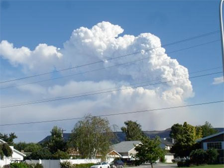
Smoke plume from the Colockum Tarps Fire visible from Pioneer Middle School in Wenatchee on the afternoon of July 28. The fire is approximately 15 miles away. Credit: WIIMT#4
Approximately 60 residences in the vicinity of Colockum, Tarpiscan and Kingsbury Roads are under Level 3 Evacuation notification. Three primary residences and several outbuildings have burned. Roads to the fire area (from both Kittitas and Chelan Counties) are closed. Kittitas County has established a Level 2 Evacuation notification in Upper Colockum Pass and Level 1 notification from Lower Colockum to Parke Creek.
Fire-fighting efforts are currently focused on improving containment lines on the North and West perimeter of the fire and continuing protection around structures. In the early afternoon, winds are likely to push the fire upslope toward the west among heavier timber fuels. In the later afternoon, winds are likely to push the fire downhill and south. A third high priority today is to determine how far the fire has burned to the South and to identify opportunities to safely prevent further spread.
There will be a community meeting tonight at the Malaga Fire Station at 7:30 to receive an update on the fire situation. There is a Red Cross Shelter open at 606 Western Avenue in Wenatchee.
Cooperating agencies include the Washington Department of Natural Resources, Bureau of Land Management, Chelan County Sheriff, Chelan County Fire District 1, Washington State Patrol, and Kittitas County Sheriff.
Fire Facts – Monday, July 29, 2013 – 0800 HOURS
- Fire Size: 20,000 acres
- Evacuations: Level 3 notification to Colockum, Tarpiscan, Kingsbury, Ingersol Roads.
- Level 2 notification Upper Colockum Pass. Level 1 notification Lower Colockum to Parke Creek.
- Closures: Roads to the fire area (Colockum, Parke Creek, Cooke Canyon, Coleman, Schnebly Canyon) are closed.
- Percent Contained: 5%
- Fuels: Grass, brush, with timber at the higher elevations
- Expected Containment: Not determined
- Air Resources: One light helicopter, one medium helicopters, two heavy helicopters. Two more medium helicopters in use.
- Firefighting Crews: 3
- Engines: 59
- Dozers: 4
- Water Tenders: 1
- Total Personnel: Approx. 300
—————————————-
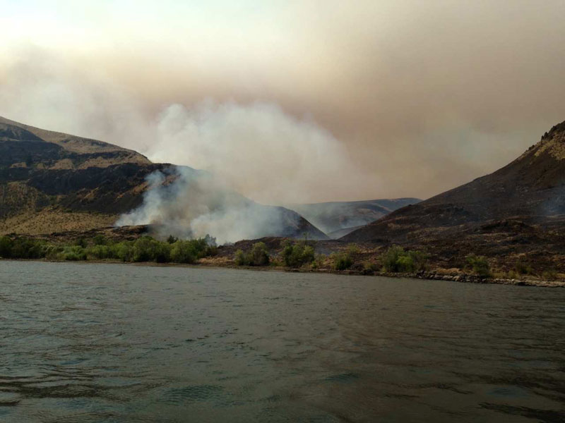
14,000 acre Chelan County Fire reaches border of Kittitas County. Photo courtesy of the Kittitas County Sheriff’s Dept.
1:40 p.m. – Kittitas County, WA -07/28/2013 – Message from The Kittitas County Sheriff’s Office to avoid recreation and travel in the Colockum Pass area as the Chelan County Fire, now estimated at 14,000 (actual total number being confirmed) acres, has reached the Northern Border of Kittitas County.
“We are requesting that all travel and recreation be avoided in the Tarpiscan, from the Clockum Pass to the Columbia River,” advised Clayton Myers, Kittitas County Undersheriff. As noted in the photograph, the fire has reached the Columbia River just north of Spanish Castle and is continuing to move South. Reports from Chelan County also state the fire is working towards the powerline road on Clockum Pass.
If you know of anyone camping in this area, please contact the Sheriff’s Office at 509-925-8534