UPDATED 8:30 a.m. Tuesday, Aug. 27, 2013 –
Cool moist weather continues – Firefighting crews take advantage of subdued fire behavior to build containment lines closer to active fire edge

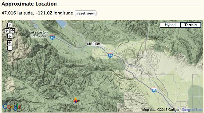
CLICK FOR LARGE DETAILED MAP. Updated Manastash Ridge Fire footprint map
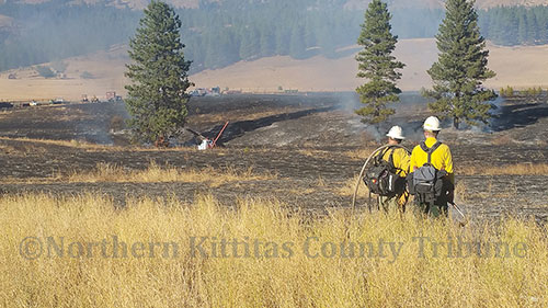
Cle Elum, Wash. – The 2,352-acre Manastash Ridge Fire has the potential to spread quickly between lichen-laden tree crowns. However, when relative humidity is high, those fine strands of lichens are much less flammable and fire behavior is subdued. Recent cool moist weather, with one quarter-inch of rain, and the knowledge built over several days of ground and aerial reconnaissance are helping fire crews to safely anchor lines and start containment work close to the fire itself.
“Getting to the stage we can implement these new tactics has truly been a team effort,” said incident commander Larry Nickey. As the fire burned actively initially, crews rapidly built and reinforced extensive contingency fire line by widening and clearing along Manastash Road (FS 3100), approximately 1.5 miles from the torching, spotting fire. As conditions allowed, firefighters have scouted out containment opportunities, helispots and safe access points closer to the fire. Today, six hotshot crews are focusing their work closer to the fire perimeter, building and reinforcing new containment lines tying into natural barriers, jeep and hiking trails.
The fire is currently only five percent contained. Without losing attention to current and expected weather and safe work conditions, swift progress is expected. Success will depend on retaining critical resources and weather. There is a chance of thunderstorms in the area today. Cool, moist weather is expected to continue through Thursday, with a return to warmer, drier weather next week.
To protect firefighter and public safety, the vicinity of this fire has been closed to public access by the Okanogan-Wenatchee National Forests. The area closure includes Township 18N, Range 14E Sections 3, 10-14, 24, 25; Township 18N, Ranger 15E Sections 8, 10, 16, 18,19-36; Township 17N, Range 15E Section 1-4. Included in the area closure are Forest Service Roads 3100 (Manastash Canyon Road), 3120, 3111, 3111-115, 3111-117, and Trails 1366, 1345, 4W311, 1350, 1385, 4W306, 694. Details of this closure boundary, a map, and other road and trail closures are available on the Okanogan-Wenatchee National Forests web site. Visitors need to drive carefully and stay out of closure areas. Only firefighters, Forest Service or other agency personnel, and law enforcement are allowed access to closure areas.
The Washington Interagency Incident Management Team #4 is also managing the 1,066-acre Conrad Lake Fire. The Conrad Lake Fire, located 35 miles southwest of Naches, is currently 25% contained. The low containment level is due to the fire having so much open line in the wilderness. Fire behavior has been minimal, due to cool weather and rain. Yesterday, the Conrad Lake Fire continued backing downhill toward Phantom Lake. Approximately 116 firefighters are mopping up and monitoring the Conrad Lake Fire and have contingency plans ready if fire behavior should change.
Conrad Lake Fire road closure information is available from Manastash Fire Information (509) 964-2138, the Naches Ranger District (509) 653-1401, or the Okanogan-Wenatchee National Forests web site.
Fire danger remains very high. Please check the Okanogan-Wenatchee National Forest website for current campfire restrictions. To stay informed of changing air quality conditions, view https://wasmoke.blogspot.com/
Manastash Ridge Fire Facts – Tuesday, August 27, 2013 – 9:00 a.m.
- Fire Size: approximately 2,352 acres
- Percent Contained: 5%
- Evacuations: No homes or structures threatened.
- Manastash Ridge Closures Summary: A detailed list of closures is available on the Okanogan-Wenatchee National Forest website. On the Naches Ranger District this includes Forest Service Road 1701 before the Funny Rocks Area and the 1900 road system leading north from Little Naches to Quartz Mountain. On the Cle Elum Ranger District, the area closure prohibits being within the boundaries of the posted closure including Forest Service Road 3100 (Manastash Canyon Road) west of the Forest Boundary.
- Fuels: Heavy ground and ladder fuels, high elevation subalpine fir and whitebark pine forest.
- Air Resources: Aircraft available to the Manastash Ridge and the Conrad Lake Fires are being shared. Two air attack platforms, two Type II helicopters and one Type III helicopter. A Type I helicopter and third Type II helicopters are expected today.
- Crews: 6 Type I crews and 13 Type II hand crews.
- Engines: 5
- Dozers: 2
- Water Tenders: 5
- Road graders: 2
- Total Personnel: 491
Conrad Lake Fire Facts – Tuesday, August 27, 2013 – 0900 HOUR
- Fire Size: approximately 1,066 acres
- Percent Contained: 25%
- Evacuations: No homes or structures threatened.
- Conrad Lake Closures Summary: Road closures near the Conrad Lake Fire include National Forest Roads 1000, 1204, 1205, 1200-725, and the 1070 between its junctions between the 1000 Road and 1070-595 Road. Trail closures include Bear Creek Mountain Trail #1130 and Conrad Meadows. Area closures include Rimrock Peninsula Recreation Area and the boat launch. There is no access from the 1200 Road onto the 1200-711, 1200-712, 1200-713, 1200-714, 1200-715, 1200-716, 1200-725, and 1200-653 roads.
- Fuels: Timber litter and understory, meadows.
- Air Resources: Aircraft available to the Manastash Ridge and the Conrad Lake Fires are being shared. Two air attack platforms, two Type II helicopters and one Type III helicopter with a Type I helicopter and additional Type II helicopter expected today.
- Crews: 2 Type II hand crews
- Engines: 4
- Dozers: 0
- Water Tenders: 5
- Total Personnel: 116
——————————————————-
UPDATED 8:30 a.m. Monday, Aug. 26, 2013 –
Storm delivers some rain, reduces fire behavior but not enough to extinguish burning forest fuels.
COMMUNITY MEETING TONIGHT IN THORP, WA
Hotshot crews join initial attack firefighters, looking for the best chances to “go direct” building fire lines closer to Manastash Ridge Fire perimeter.
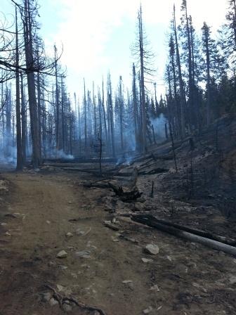
Area where subalpine trees, woody debris and ground vegetation have been mostly consumed by the fire.
Credit: Washington Interagency Incident Management Team #4
Cle Elum, Wash. – The 2,352-acre Manastash Ridge Fire has been burning for a week in high-elevation subalpine fir forest above one of the Okanagan-Wenatchee National Forests’ geological marvels of the same name – seemingly unaffected by water and retardant drops from helicopters, airtankers, and even heavy rains from several storms. The fire is currently five percent contained.
After doubling in size last Thursday, the slow-moving fire has continued to slowly back down heavily forested slopes behind the 2,000 foot-high Ridge, hopping tree-to-tree igniting lichens that hang from low branches. These lichens typically absorb a lot of moisture from the air …but also dry out quickly. When dry, the lichens catch fire and cause trees to torch. Higher relative humidity over the past several days has helped to slow tree torching and fire growth. However, the active fire, spot fires, and rugged terrain have prevented firefighters from safely approaching the fire perimeter.
The strategy adopted by the incident management team charged with suppressing the fire has been to first construct containment lines along existing roads away from the fire. They plan to use those cleared lines as an “outer box” that would prevent the fire’s spread, should winds and weather activate the fire and send it racing to the north, away from the Ridge face. This strategy is referred to as taking indirect fire suppression action. This big box is about 10,000 acres in size.
Today, most of that outer box is complete. With recent precipitation, firefighters are getting a chance to move in closer to the fire, and prepare direct line along edges where it is safe to approach. Fifteen firefighting crews, including three Pacific Northwest hotshot crews and the original, initial attack firefighters, are preparing for this job. They spent most of Sunday scouting for the best locations for a constructing a smaller, 3,800-acre “box” around the fire.
According to Larry Nickey, incident commander for the Washington Interagency Incident Management Team #4, firefighter and public safety will not be compromised at this or any wildfire. “We will use the safest tactics necessary to accomplish this suppression mission.”
“This fire is not threatening homes, communities or structures in the immediate area. We are looking for opportunities to create fire lines where the fire might escape.” Most of the work over the past 5 days has been brushing, grading and chipping to widen, clear and strengthen Forest Service Road 3100 (Manastash Canyon Road), approximately 1.5 miles from the fire while waiting for higher relative humidity to allow work closer to the fire.
The Manastash Ridge Fire is burning on difficult, shallow soils over basalt rock through dense forests. The fire has been observed from the air daily to monitor its slow growth. Even though the area is known for its treeless, fields of talus, it would seem to the common observer that fires could not spread beyond them. Fire crews are mopping up timber islands along the steep, rocky face of the Ridge that forms the southern perimeter of the fire.
“Not true,” says Dean Warner, fire and fuel behavior analyst for the Team. “This talus is filled with dry, fine, plant material that burns hot. Embers from burning trees that fall into the talus will catch logs and debris on fire and carry the fire into small islands of trees and allow the fire to spread to forest on the other side,” he said.
Warner said the fire, which is five percent contained, continued to burn Sunday even after the rain that fell earlier in the day. “The rain has little effect, as the large-diameter, downed logs were dry again shortly after the storm passed,” he said.
As the Fire has continued to cause small spot fires along an irregular fire perimeter and firefighting activities are increasing, the Okanogan-Wenatchee National Forests established an area closure last Saturday to eliminate access to the area surrounding the fire. The area closure includes Township 18N, Range 14E Sections 3, 10-14, 24, 25; Township 18N, Ranger 15E Sections 8, 10, 16, 18,19-36; Township 17N, Range 15E Section 1-4. Included in the area closure are Forest Service Roads 3100 (Manastash Canyon Road), 3120, 3111, 3111-115, 3111-117, and Trails 1366, 1345, 4W311, 1350, 1385, 4W306, 694. Details of the closure boundary and other road and trail closures are available on the Okanogan-Wenatchee National Forests web site.To ensure public and firefighter safety, visitors need to drive carefully and stay out of closure areas. Only firefighters, Forest Service or other agency personnel, and law enforcement are allowed access to closure areas.
A community meeting about the Manastash Ridge Fire, including the closure orders, will take place tonight (Monday, August 26, 2013) at the Thorp Fire Station at 7 p.m. The fire station is located at 10700 N Thorp Highway in the town of Thorp, Wash.
The Washington Interagency Incident Management Team #4 is also managing the 1,066-acre Conrad Lake Fire. The Conrad Lake Fire, located 35 miles southwest of Naches, is currently 25% contained. The low containment level is due to the fire having so much open line in the wilderness. Yesterday, the Conrad Lake Fire continued backing downhill toward Phantom Lake. Approximately 150 firefighters are mopping up and monitoring the Conrad Lake Fire.
Radio communications between the Conrad Lake Fire and Manastash Ridge Fire and Incident Command Post were established late yesterday.
Visitors should be aware of closures and monitor web sites or call Manastash Fire Information at (509) 964-2138 for the latest Conrad Lake Fire closure information.
Fire danger remains very high. Please check the Okanogan-Wenatchee National Forest website for the current campfire restrictions. To stay informed of changing air quality conditions, view https://wasmoke.blogspot.com/
Manastash Ridge Fire Facts – Monday, August 26, 2013 – 9:00 a.m.
- Fire Size: approximately 2,352 acres
- Percent Contained: 5%
- Evacuations: No homes or structures threatened.
- Manastash Ridge Closures Summary: A detailed list of closures is available on the Okanogan-Wenatchee National Forest website. On the Naches Ranger District this includes Forest Service Road 1701 before the Funny Rocks Area and the 1900 road system leading north from Little Naches to Quartz Mountain. On the Cle Elum Ranger District, the expanded area closure prohibits being within the boundaries of the posted closure including Forest Service Road 3100 (Manastash Canyon Road) west of the Forest Boundary.
- Fuels: Heavy ground and ladder fuels, high elevation subalpine fir and whitebark pine forest.
- Air Resources: Two air attack platforms, two Type II helicopters and one Type III helicopter.
- Crews: 12 Type II hand crews, 3 Type I crews
- Engines: 4
- Dozers: 2
- Water Tenders: 5
- Road graders: 2
- Total Personnel: Approx. 418 (122 overhead)
Conrad Lake Fire Facts – Monday, August 26, 2013 – 9:30 a.m.
- Fire Size: approximately 1,066 acres
- Percent Contained: 25%
- Evacuations: No homes or structures threatened.
- Conrad Lake Closures Summary: Road closures near the Conrad Lake Fire include National Forest Roads 1000, 1204, 1205, 1200-725, and the 1070 between its junctions between the 1000 Road and 1070-595 Road. Trail closures include Bear Creek Mountain Trail #1130 and Conrad Meadows. Area closures include Rimrock Peninsula Recreation Area and the boat launch. There is no access from the 1200 Road onto the 1200-711, 1200-712, 1200-713, 1200-714, 1200-715, 1200-716, 1200-725, and 1200-653 roads.
- Fuels: Timber litter and understory, meadows.
- Air Resources: Two air attack platforms, two Type II helicopters and one Type III helicopter (shared with Manastash Ridge Fire)
- Crews: 3 Type II crews
- Engines: 4
- Dozers: 0
- Water Tenders: 6
- Road graders: 0
- Total Personnel: Approx. 146 (47 overhead)
—————————————————–
UPDATED 10:30 a.m. Sunday, Aug. 25, 2013 –
Storm front expected to arrive later today, bringing with it needed rain, erratic winds, lightning
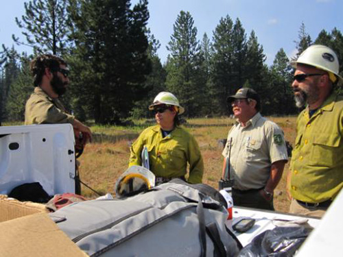
Division briefing on Manastash Ridge Fire.
August 24, 2013.
Credit: Pam Wilkens
Manastash Ridge Fire now 2,320 acres burning in high elevation forest near Cle Elum, Washington
Cle Elum, Wash. – The 2,320-acre Manastash Ridge Fire, mapped by infrared flight, continues to burn in the high-elevation forest in the Okanogan-Wenatchee National Forests, 12 miles southwest of Cle Elum, Wash. There was limited fire growth on the fire perimeter yesterday, but erratic winds and potential lightning from a storm moving through the area later today may increase fire behavior – even though the storm is predicted to bring some much-needed rain.
Yesterday, firefighters had a successful day keeping the south side of the Fire along the bluffs secure. Crews also started preparing Forest Service Road 3100 (Manastash Canyon Road) as a contingency fire line north of the Fire, and continued to scout for better locations for containment line closer to the fire perimeter. Today, operations will continue to work on securing the contingency line and continue evaluating line construction closer to the current fire perimeter.
Ensuring the safety of firefighters working in this rugged area is the top priority. Proposed suppression actions keep firefighters safely away from the fire, allowing time for limited resources to complete fire lines. Firefighters were advised by Larry Nickey, incident commander for the Washington Interagency Incident Management Team #4 that has been managing the fire since last Thursday, to be extremely careful as personnel evaluate taking a more direct attack on the fire if increased relative humidity allows.
Road and trail closures have been expanded to an additional area closure in the Manastash Ridge area due to fire operations in the area. It is prohibited to be within the closure area of Township 18N, Range 14E Sections 3, 10-14, 24, 25; Township 18N, Ranger 15E Sections 8, 10, 16, 18,19-36; Township 17N, Range 15E Section 1-4. Included in the area closure are Forest Service Roads 3100 (Manastash Canyon Road), 3120, 3111, 3111-115, 3111-117, and Trails 1366, 1345, 4W311, 1350, 1385, 4W306, 694. To ensure public and firefighter safety, visitors need to drive carefully and stay out of closure areas. Only firefighters, Forest Service or other agency personnel, and law enforcement are allowed access to closure areas. A detailed list of the closure boundary and other road and trail closures is available on the Manastash Ridge Inciweb page.
A community meeting about the Manastash Ridge fire, including the closure orders, will take place at the Thorp Fire Station at 7pm on Monday, August 26, 2013. The fire station is located at 10700 N Thorp Hwy in the town of Thorp.
The Manastash Ridge Fire was started by lightning along with approximately 30 others on August 9. All of the local fires started on August 9 except this one and the Conrad Lake Fire were controlled by initial attack forces.
The Manastash Ridge Fire, burning at 6,000 feet elevation in subalpine fir/whitebark pine forest types, became active on Monday, August 19. Jumpers and rappellers attempted to make use of natural rock barriers, helicopter water bucket drops and some retardant to slow fire spread. Retardant dropped along the east flank of the fire and along the rim of the Ridge Wednesday was not effective in stopping the spread of the fire because gusty winds were producing ¼-mile spotting. Reconnaissance efforts continued last Thursday and Friday to find access points and potential containment line.
The Washington Interagency Incident Management Team #4 is also managing the Conrad Lake Fire. The Conrad Lake Fire, located 35 miles southwest of Naches, covers approximately 1,000 acres and is currently 25% contained. The low containment level is due to the fire having so much open line in the wilderness. Yesterday the Conrad Lake Fire is started to slowly back toward Phantom Lake. Smoke will continue to be visible today. Management of the Conrad Lake Fire is in a monitoring phase with 150 people assigned.
Road closures near the Conrad Lake Fire include National Forest Roads 1000, 1204, 1205, 1200-725, and the 1070 between its junctions between the 1000 Road and 1070-595 Road. Trail closures include Bear Creek Mountain Trail #1130 and Conrad Meadows. Area closures include Rimrock Peninsula Recreation Area and the boat launch. There is no access from the 1200 Road onto the 1200-711, 1200-712, 1200-713, 1200-714, 1200-715, 1200-716, 1200-725, and 1200-653 roads.
Visitors should be aware of closures and monitor web sites or call Manastash Fire Information at the new fire information phone number (509) 964-2138 for the latest closure information.
Fire danger remains very high. Please check the Okanogan-Wenatchee National Forest website for the current campfire restrictions. To stay informed of changing air quality conditions, view https://wasmoke.blogspot.com/
Manastash Ridge Fire Facts – Sunday, August 25, 2013 – 9:00 a.m.
- Fire Size: approximately 2,320 acres
- Percent Contained: 0%
- Evacuations: No home or structures threatened.
- Manastash Ridge Closures Summary: A detailed list of closures is available on the Okanogan-Wenatchee National Forest website and the Manastash Ridge Inciweb page. On the Naches Ranger District this includes Forest Service Road 1701 before the Funny Rocks Area and the 1900 road system leading north from Little Naches to Quartz Mountain. On the Cle Elum Ranger District, the expanded area closure prohibits being within the boundaries of the posted closure including Forest Service Road 3100 (Manastash Canyon Road) west of the Forest Boundary.
- Fuels: Heavy ground and ladder fuels, high elevation subalpine fir and whitebark pine forest.
- Air Resources: Two air attack platforms, two Type II helicopters and one Type III helicopter.
- Crews: 9 Type II hand crews
- Engines: 0 Dozers: 2 Water Tenders: 5 Road graders: 2
- Total Personnel: Approx. 301 (96 overhead)
————————————————
UPDATED 10:00 a.m. Aug. 24, 2013 –
Subdued fire activity and smoke due to cool, moist weather conditions.

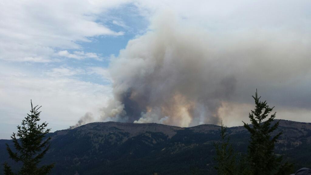
Bucket Drop on Manastash Ridge Fire 8/22/13. Credit: Jared Treser
Manastash Ridge Fire now 2,320 acres burning in high elevation forests near Cle Elum, Washington
Cle Elum, WA – The Manastash Ridge Fire, mapped for the first time yesterday from aircraft, is now estimated to cover 2,320 acres of high-elevation forests in the Okanogan-Wenatchee National Forest. The fire is approximately 12 miles southwest of Cle Elum, Wash., near Shoestring Lake on the North side of the Manastash Ridge Trail, approximately three miles southwest of Manastash Camp. Cooler, moist weather Friday reduced fire activity and growth, producing less visible smoke. This weather pattern is expected to continue through the weekend.
The Washington Interagency Incident Management Team #4, under the command of Larry Nickey, incident commander, is managing the Manastash Ridge Fire and also took over management of the Conrad Lake Fire at 6 a.m. today. The Conrad Lake Fire, located 35 miles southwest from Naches, covers approximately 1,000 acres and is currently 25% contained. The low containment level is due to the fire having so much open line in the wilderness. Management of the Conrad Lake Fire is in a monitoring phase with 150 people assigned. 216 personnel are currently working on the Manastash Ridge Fire, including 9 firefighting crews, 1 falling crew, and 3 helicopters.
These fires are not threatening homes or structures at this time. Despite cooler, moist weather, gusty winds may cause occasional torching and spotting in the Manastash Ridge Fire. The ground is extremely difficult to access over the basalt rock terrain. Roads into the area are very rough, but dozers and graders are being used to improve access. Fire suppression activities are focused on keeping the fire from spotting into stringers of timber below and south of the Ridge. Forest Service Road 3100 (Manastash Canyon Road) will be used as the contingency containment line to the north of the Manastash Fire. Several small fires ignited by lightning on August 22 near Highway 12 west of Naches are being suppressed by initial attack crews and helicopter water drops.
Road and trail closures around both fire areas remain in effect. The Forest Service may expand the closure area around Manastash Ridge due to changing fire conditions and increased firefighter traffic. These popular outdoor recreation and hunting areas will see increased public and firefighter traffic over the weekend. To ensure public and firefighter safety, visitors need to drive carefully and stay out of closure areas. Only firefighters, Forest Service or other agency personnel, and law enforcement are allowed access to closure areas. Closure notices have been posted at trailheads and other entry points. A detailed list of closures is available on the Okanogan-Wenatchee National Forest website.
The current strategy for managing the Manastash Ridge Fire is a combination of indirect attack by establishing contingency lines, use of natural fire barriers, and some direct control. Operational tactics being used today include reconnaissance, improving access, and fire line preparation. Divisions on the south perimeter will be suppressing spot fires and preventing movement of fire through timber stringers into unburned forests to the south. Ensuring the safety of firefighters working in this rugged area is the top priority. The proposed actions keep firefighters safely away from the fire, allowing time for limited resources to complete fire lines. Today, eight additional 20-person fire crews have been assigned to the Manastash Ridge Fire.
The Manastash Ridge Fire was started by lightning, along with approximately 30 others on August 9. All of the local fires started on August 9 except this one and the Conrad Lake Fire were controlled by initial attack forces. The Manastash Ridge Fire, burning at 6,000 feet elevation in subalpine fir/whitebark pine forest types, became active on Monday, August 19. Jumpers and rappellers attempted to make use of natural rock barriers, helicopter water bucket drops and some retardant to slow fire spread. Retardant dropped along the east flank of the fire and along the rim of the Ridge Wednesday was not effective in stopping the spread of the fire because gusty winds were producing ¼-mile spotting.
There is no estimated containment of the Manastash Ridge Fire at this time.
Road and trail closures south of the Manastash Ridge Fire include Forest Service Road 1701 before the Funny Rocks Area and the 1900 road system leading north from Little Naches to Quartz Mountain. On the Cle Elum side, closures include the Manastash Ridge Trail, Shoestring Trail, and roads south from Manastash and Rider’s Camps. Manastash Canyon Road (FS Road 3100) is open to Quartz Mountain. Road closures near the Conrad Lake Fire include National Forest Roads 1000, 1204, 1205, 1200-725, and the 1070 between its junction with the 1000 to its junction with 1070-595. Trail closures include Bear Creek Mountain trail #1130 and Conrad Meadows. Area closures include Rimrock Peninsula Recreation Area and the boat launch. There is no access from the 1200 road onto the 1200-711, 1200-712, 1200-713, 1200-714, 1200-715, 1200-716, 1200-725, and 1200-653 roads. Current closure information is available on the Okanogan-Wenatchee National Forest website.
Roads near the fire will continue to be assessed for closure needs. Closures will depend upon fire activity, weather conditions, and other factors. Visitors should be aware of closures and monitor web sites or call Manastash Fire Information at (509) 607-6321.
To stay informed of changing air quality conditions, view https://wasmoke.blogspot.com/
Manastash Ridge Fire Facts – Saturday, August 24, 2013 – 9:00 a.m.
- Fire Size: approximately 2,320 acres
- Percent Contained: 0%
- Evacuations: No home or structures threatened.
- Manastash Ridge Closures Summary: A detailed list of closures is available on the Okanogan-Wenatchee National Forest website. On the Naches side this includes Forest Service Road 1701 before the Funny Rocks Area and the 1900 road system leading north from Little Naches to Quartz Mountain. On the Cle Elum side, closures include the Manastash Ridge Trail, Shoestring Trail, and roads south from Manastash and Rider’s Camps. Manastash Canyon Road (FS Road 3100) is open to Quartz Mountain.
Fuels: Heavy ground and ladder fuels, high elevation subalpine fir and whitebark pine forest. - Air Resources: Two air attack platforms, two Type II helicopters and one Type III helicopter.
- Crews: 9 Type II hand crews and 1 feller crew
- Engines: 0
- Dozers: 2
- Water Tenders: 3
- Total Personnel: Approx. 216 (68 overhead)
——————————————————————–
Credit: Shea Hurley
Smoke visible from many communities but no structures threatened
1,000-acre Manastash Ridge Fire burning through high elevation forests near Cle Elum, Washington
10:00 a.m. Friday, Aug. 23, 2013 – Cle Elum, WA – The Manastash Ridge Fire, burning in the high-elevation forests of the Okanogan-Wenatchee National Forests, has grown to approximately 1,000 acres. The fire is approximately 12 miles southwest of Cle Elum, Wash., near Shoestring Lake on the North side of the Manastash Ridge Trail, approximately three miles southwest of Manastash Camp. The smoke it is producing is clearly visible from surrounding communities.
The Washington Interagency Incident Management Team #4, under the command of Larry Nickey, incident commander, took control of the fire at 6 a.m. today.
The Fire is not threatening homes or structures at this time, but is producing a smoke column that can be seen from the towns of Ellensburg, Naches, Yakima and Cle Elum, Wash. Winds out of the west are expected to carry smoke throughout the Kittitas Valley and as far east as Ellensburg today.
 The fire grew nearly 400 acres to the north late yesterday afternoon, nearly doubling the fire size. Last night, a thermal belt over the fire area kept temperatures high and fire activity high. Today, erratic winds generated by thunderstorm cells are predicted.
Presently, the fire is torching and spotting, and moving slowly to the east along the top of the Manastash Ridge. The ground is extremely difficult to access over the basalt rock terrain. There are very few roads into the area. Fire suppression activities are focused on keeping the fire from spotting into stringers of timber below and south of the Ridge.
The operational tactics being used today include reconnaissance from the air and by ground, evaluating conditions to determine where firefighters can directly fight the fire. Three 20-person fire crews are expected to arrive today. Meanwhile, initial attack firefighters and a Type II firefighting crew will prepare fire lines east of the active fire perimeter — tying their lines into rocky outcrops and natural barriers. The action keeps firefighters safely away from the fire. The fire will be allowed to burn to the strengthened lines.
The fire was started by lightning, along with approximately 30 others on August 9. All of the local fires except this one and the Conrad Lake Fire were controlled by initial attack forces. The Manastash Ridge Fire, burning at 6,000 feet elevation in subalpine fir/whitebark pine forest types, became active on Monday, August 19. Jumpers and rappellers attempted to make use of natural rock barriers, helicopter water bucket drops and some retardant to slow fire spread. Retardant dropped along the east flank of the fire and along the rim of the Ridge Wednesday was not effective in stopping the spread of the fire because gusty winds were producing ¼-mile spotting.
There is no estimated containment at this time.
The Manastash Ridge area is popular with hunters, hikers and off-road recreationists. An emergency closure of several road and trail systems leading into the fire area has been implemented by the Cle Elum and Naches ranger districts to ensure public and firefighter safety. Only firefighters, Forest Service or other agency personnel, and law enforcement are allowed access to these areas. Closure notices have been posted at trailheads and other entry points on both the Cle Elum and Naches sides of Manastash Ridge. A detailed list of closures is available on the Okanogan-Wenatchee National Forest website. On the Naches side this includes Forest Service Road 1701 before the Funny Rocks Area and the 1900 road system leading north from Little Naches to Quartz Mountain. On the Cle Elum side, closures include the Manastash Ridge Trail, Shoestring Trail, and roads south from Manastash and Rider’s Camps. Manastash Canyon Road (FS Road 3100) is open to Quartz Mountain.
Roads near the fire will continue to be assessed for closure needs. Closures will depend upon fire activity, weather conditions, and other factors. Visitors should be aware of closures and monitor web sites or call Menastash Fire Information at (509) 607-6321.
To stay informed of changing air quality conditions, view https://wasmoke.blogspot.com/
Fire Facts – Friday, August 23, 2013 – 9:00 a.m.
- Fire Size: approximately 1,000 acres
- Percent Contained: 0%
- Evacuations: No home or structures threatened.
- Manastash Ridge Closures Summary: A detailed list of closures is available on the Okanogan-Wenatchee National Forest website. On the Naches side this includes Forest Service Road 1701 before the Funny Rocks Area and the 1900 road system leading north from Little Naches to Quartz Mountain. On the Cle Elum side, closures include the Manastash Ridge Trail, Shoestring Trail, and roads south from Manastash and Rider’s Camps. Manastash Canyon Road (FS Road 3100) is open to Quartz Mountain.
Fuels: Heavy ground and ladder fuels, high elevation subalpine fir and whitebark pine forest. - Air Resources: One air attack platform, two Type II helicopters and one Type III are available from Conrad Lake Fire if needed.
- Crews: Feller Crew, 1 Type II Crew
- Engines: 0
- Dozers: 1
- Water Tenders: 0
- Total Personnel: Approx. 100 (55 overhead)